Image:Great Moravia-eng.png
From Wikipedia, the free encyclopedia
Size of this preview: 565 × 479 pixels
Full resolution (1,323 × 1,122 pixels, file size: 529 KB, MIME type: image/png)
| |
This is a file from the Wikimedia Commons. The description on its description page there is shown below. |
Opis súboru
| Description |
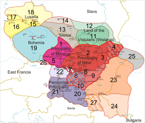
Historical map of Great Moravia |
|---|---|
| Source |
self-made; based on Image:Europe-slk.svg (which is based on CIA World Factbook (image), geodesy.gov.sk, Wikipedia (Slovak labels)) |
| Date |
28.7.2007 |
| Author |
Bronto, ~~ Helix84 |
| Permission ( Reusing this image) |
see below |
| Other versions | see below |
This cropped image is exported from the vector source: Image:Great Moravia not cropped, eng labels.svg
All related images (exported from same source):
 Vector source, no labels |
 Vector source, German labels |
 Vector source, English labels |
 Vector source, French labels |
 Vector source, Slovak labels |
 Cropped export, no labels |
 Cropped export, German labels |
 Cropped export, English labels |
 Cropped export, French labels |
 Cropped export, Slovak labels |
Legenda:
1: od 833 do 907: Moravské kniežatstvo
2: od 833 do 907: Nitrianske kniežatstvo
3: spolu s  2 alebo spolu s 4
4: od 833 alebo od vlády Rastislava do (?)896: Nitrianske kniežatstvo
5: spolu s 1 alebo od roku 853/54 do (?)907: Moravské kniežatstvo
6: od roku 858 do (?)894: Nitrianske kniežatstvo
7: spolu s 2 alebo spolu s 22:
8: spolu s 6 alebo spolu s 20
9: od vlády Rastislava (846-870) alebo Svätopluka I. (871-894) do 896: Nitrianske kniežatstvo
10: spolu s 8 alebo spolu s 20
11: od 874 do (?) 907: Visliansko
12: pravdepodobne spolu s 11
13: od 880 do ?: Sliezsko (podľa niektorých názorov nebolo pripojené)
14: pravdepodobne spolu s 14
15: od 890 do 897: Lužica
16: veľmi pravdepodobne spolu s 15
17: veľmi pravdepodobne spolu s 15
18: pravdepodobne spolu s 15-17
19: od 888/890 do 894: Čechy
20: od 883/884 do 894: Panónske kniežatstvo
21: veľmi pravdepodobne spolu s 20
22: spolu s 20 (a 21): možno Panónske kniežatstvo
23: od 881/882 do 896: Zátisie
24: pravdepodobne spolu s 23
25: od vlády Svätopluka (871-894) do (?) 896
26: od vlády Svätopluka (871-894) do ?
27: spolu s 23 alebo spolu s 24
Legend:
yellow lines: current borders
blue lines: rivers
red dots: main castles/settlements
1: from 833 to 907: Principality of Moravia
2: from 833 to 907: Principality of Nitra
3: along with 2 or along with 4
4: from 833 or from the reign of Rastislav to (?)896: Principality of Nitra
5: along with 1 or from 853/54 to (?)907: Princiaplity of Moravia
6: from 858 to (?)894: Principality of Nitra
7: along with 2 or along with 22
8: along with 6 or along with 20
9: from the reign of Rastislav (846-870) or of Svätopluk I (871-894) to 896: Principality of Nitra
10: along with 8 or along with 20
11: from 874 to (?) 907: Wislania
12: probably along with 11
13: from 880 to ?: Silesia (Silesia was not annexed according to some authors)
14: probably along with 14
15: from 890 to 897: Lusatia
16: with a high probability along with 15
17: with a high probability along with 15
18: probably along with 15-17
19: from 888/890 to 894: Bohemia
20: from 883/884 to 894: Pannonian Principality (Balaton Principality)
21: with a high probability along with 20
22: along with 20 (and 21): maybe part of the Pannonian Principality (Balaton Principality)
23: from 881/882 to 896: "Transtheissia"
24: probably along with 23
25: from the reign of Svätopluk (871-894) to (?) 896
26: from the reign of Svätopluk (871-894) to ?
27: along with 23 or along with 24
Legende:
gelbe Linien: aktuelle Grenzen
blaue Linien: Flüsse
rote Punkte: die wichtigsten Burgwälle/Siedlungen
1: von 833 bis 907: Mährisches Fürstentum
2: von 833 bis 907: Neutraer Fürstentum
3: zusammen mit 2 oder zusammen mit 4
4: von 833 oder von der Regierungszeit Rastislavs bis (?)896: Neutraer Fürstentum
5: zusammen mit 1 oder von 853/54 bis (?)907: Mährisches Fürstentum
6: von 858 bis (?)894: Neutraer Fürstentum
7: zusammen mit 2 oder zusammen mit 22
8: zusammen mit 6 oder zusammen mit 20
9: von der Regierungszeit Rastislavs (846-870) oder Sventopluks I. (871-894) bis 896: Neutraer Fürstentum
10: zusammen mit 8 oder zusammen mit 20
11: von 874 bis (?) 907: Wislanenland
12: wahrscheinlich zusammen mit 11
13: von 880 bis ?: Schlesien (Schlesien wurde einigen Autoren zufolge nicht angeschlossen)
14: wahrscheinlich zusammen mit 14
15: von 890 bis 897: Lausitz
16: höchstwahrscheinlich zusammen mit 15
17: höchstwahrscheinlich zusammen mit 15
18: wahrscheinlich zusammen mit 15-17
19: von 888/890 bis 894: Bohemia
20: von 883/884 bis 894: Plattensee-Fürstentum
21: höchstwahrscheinlich zusammen mit 20
22: zusammen mit 20 (und 21): vielleicht Teil des Plattensee-Fürstentums
23: von 881/882 bis 896: "Transtheissia"
24: wahrscheinlich zusammen mit 23
25: von der Regierungszeit Sventopluks (871-894) bis (?) 896
26: von der Regierungszeit Sventopluks (871-894) bis ?
27: zusammen mit 23 oder zusammen mit 24
Légende:
Lignes jaunes: frontières actuelles
Lignes bleues: rivières
Points rouges: châteaux forts principaux/colonies principales
1: de 833 à 907: Principauté de Moravie
2: de 833 à 907: Principauté de Nitra
3: en même temps que 2 ou en même temps que 4
4: de 833 ou du règne de Rastislav à (?)896: Principauté de Nitra
5: en même temps que 1 ou de 853/54 à (?)907: Principauté de Moravie
6: de 858 à (?)894: Principauté de Nitra
7: en même temps que 2 ou en même temps que 22
8: en même temps que 6 ou en même temps que 20
9: du règne de Rastislav (846-870) ou de Svätopluk I (871-894) to 896: Principauté de Nitra
10: en même temps que 8 ou en même temps que 20
11: de 874 à (?) 907: Pays des Vistuliens
12: probablement en même temps que 11
13: de 880 à ?: Silésie (la Silésie n‘a pas été annexée d’après quelques auteurs)
14: probablement en même temps que 14
15: de 890 à 897: Lusatie
16: très probablement en même temps que 15
17: très probablement en même temps que 15
18: probablement en même temps que 15-17
19: de 888/890 à 894: Bohême
20: de 883/884 à 894: Principauté de Pannonie
21: très probablement en même temps que 20
22: en même temps que 20 (and 21): peut-être une partie de la Principauté de Pannonie
23: de 881/882 à 896
24: probablement en même temps que 23
25: du règne de Svätopluk (871-894) à (?) 896
26: du règne de Svätopluk (871-894) à ?
27: en même temps que 23 ou en même temps que 24
Main sources:
Čaplovič, Dušan: Včasnostredoveké osídlenie Slovenska, 1998, Bratislava
Dvořák, Pavel: Stopy dávnej minulosti – Zrod národa, 2004, Bratislava
Frolík, Jan et al.:  Velké dějiny zemí Koruny české I., 1999, Praha
Gurňák, Daniel: Štáty v premenách storočí – Dejepisný atlas, 2006, Bratislava
Kováč, Dušan et al.: Kronika Slovenska 1., 1998, Bratislava
Marsina, Richard et al.:  Dejiny Slovenska I., 1986, Bratislava
Ratkoš, Peter: Slovensko v dobe veľkomoravskej, 1988, Košice
Segeš, Vladimír; Višváder, František: Kniha kráľov - Panovníci v dejinách Slovenska a Slovákov, 1998, Bratislava
Steinhübel, Ján: Nitrianske kniežatstvo, 2004, Bratislava
Štefanovičová, Tatiana: Osudy starých Slovanov, 1989, Bratislava
Třeštík, Dušan: Vznik Velké Moravy. Moravané, Čechové a střední Evropa v letech 781-871, 2001, Praha
Licensing
|

File history
Click on a date/time to view the file as it appeared at that time.
| Date/Time | Dimensions | User | Comment | |
|---|---|---|---|---|
| current | 21:43, 28 July 2007 | 1,323×1,122 (529 KB) | Helix84 | (== Opis súboru == {{Information |Description=Historical map of Great Moravia |Source=self-made; based on Image:Europe-slk.svg (which is based on CIA World Factbook (image), geodesy.gov.sk, Wikipedia (Slovak labels)) |Date=28.7.20) |