Image:Montreal2006.png
From Wikipedia, the free encyclopedia
Size of this preview: 640 × 330 pixels
Full resolution (832 × 429 pixels, file size: 99 KB, MIME type: image/png)
| |
This is a file from the Wikimedia Commons. The description on its description page there is shown below. |
| Description |
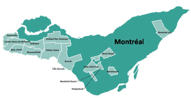
English: Map self-designed, political map of Montreal
|
|---|---|
| Source |
Transferred from en.wikipedia |
| Date |
2005-05-05 (first version); 2007-11-26 (last version) |
| Author |
Original uploader was Hardouin at en.wikipedia Later version(s) were uploaded by Solarcaine, Nat at en.wikipedia. |
| Permission ( Reusing this image) |
GFDL-WITH-DISCLAIMERS; Released under the GNU Free Documentation License.
|
License information
 |
Permission is granted to copy, distribute and/or modify this document under the terms of the GNU Free Documentation License, Version 1.2 or any later version published by the Free Software Foundation; with no Invariant Sections, no Front-Cover Texts, and no Back-Cover Texts. Subject to disclaimers. Asturianu | Български | Català | Deutsch | English | Español | Français | Gaeilge | Italiano | Polski | Português | +/- |
Original upload log
The original description page is/was here. All following user names refer to en.wikipedia.
- 2007-11-26 09:03 Nat 832×429×8 (101860 bytes)
- 2006-03-25 12:32 Solarcaine 643×533×8 (11229 bytes)
- 2005-05-05 15:58 Hardouin 643×533×8 (20632 bytes) {{GFDL}} Map self-dezigned
File history
Click on a date/time to view the file as it appeared at that time.
| Date/Time | Dimensions | User | Comment | |
|---|---|---|---|---|
| current | 09:01, 26 November 2007 | 832×429 (99 KB) | Nat | |
| 04:00, 3 January 2006 | 643×533 (20 KB) | Gene.arboit | (Political map of Montreal, 2006. Source: en:Image:Montreal2001.png Category:Montreal geography) |
File links
The following pages on Schools Wikipedia link to this image (list may be incomplete):