Image:Bih 1991.jpg
From Wikipedia, the free encyclopedia
Size of this preview: 519 × 479 pixels
Full resolution (800 × 739 pixels, file size: 215 KB, MIME type: image/jpeg)
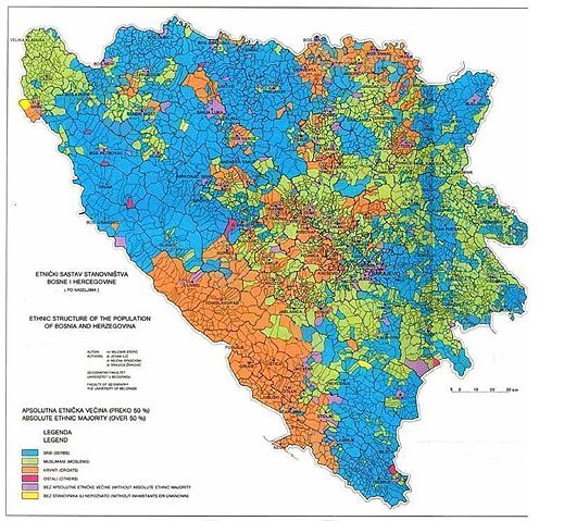
BiH ethnic map my communinies in 1991 before the war
| |
This image was uploaded in the JPEG format even though it consists of non-photographic data. The information it contains could be stored more efficiently or more accurately in the PNG format or SVG format. If possible, please upload a PNG or SVG version of this image, derived from a non-JPEG source so that it doesn't contain any compression artifacts (or with existing artifacts removed) and with transparency where appropriate. After doing so, please replace all instances of the JPEG version throughout Wikipedia (noted under the "File links" header), tag the JPEG version with {{ obsolete|NewImage.ext}}, and remove this tag. For more information, see Wikipedia:Preparing images for upload. |
Licensing
 |
This work has been released into the public domain by the copyright holder. This applies worldwide. In case this is not legally possible: |
There are possible inaccuracies comparing 1981 map to 1991
   * western part of Bosnia (Bihać, B.Krupa and Sanski Most)
   * central Bosnia (where Serbian settlements became Muslim in Zenica, Bugojno, Žepče and Kakanj and partially in Zavidovići and Maglaj municipalities)
   * northern Bosnia (Gradačac, Šamac, Modriča,Doboj)
   * eastern Bosnia (Bratunac, Srebrenica, Zvornik, Vlasenica, Kladanj, Kalesija, Olovo, Višegrad, Rudo, Goražde, Čajniče and Foča
   * Sarajevo area (it's municipalities without Pale)
And more Croat setlements in:
   * Posavina (Šamac, Odžak, Brod and Derventa)
   * Central Bosnia (N.Travnik, Kreševo, Gornji Vakuf)
   * Herzegovina (Kupres, Tomislavgrad, Prozor, Konjic, Jablanica, Mostar, Neum, Čapljina, Trebinje)
which are courantly being checked.
File history
Click on a date/time to view the file as it appeared at that time.
| Date/Time | Dimensions | User | Comment | |
|---|---|---|---|---|
| current | 20:54, 11 June 2007 | 800×739 (215 KB) | Ceha ( Talk | contribs) | (BiH ethnic map my communinies in 1991 before the war) |
See the setup instructions for more information.
File links
The following pages on Schools Wikipedia link to this image (list may be incomplete):
Categories: Images with inappropriate JPEG compression | Copyright holder released public domain images