Image:Bk-map.png
From Wikipedia, the free encyclopedia
No higher resolution available.
Bk-map.png (326 × 350 pixels, file size: 16 KB, MIME type: image/png)
| |
This is a file from the Wikimedia Commons. The description on its description page there is shown below. |
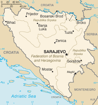
Bosnia and Herzegovina map from CIA World Factbook
 |
This image is in the public domain because it contains materials that originally came from the United States Central Intelligence Agency's World Factbook. Deutsch | English | Español | Français | 日本語 | Nederlands | 한국어 | Português | தமிழ் | Magyar | +/- |
 |
File history
Click on a date/time to view the file as it appeared at that time.
| Date/Time | Dimensions | User | Comment | |
|---|---|---|---|---|
| current | 09:46, 6 July 2006 | 326×350 (16 KB) | Cantus | (new CIA version to denote Montenegro as an independent state) |
| 09:46, 6 July 2006 | 326×350 (16 KB) | Cantus | (new CIA version to denote Montenegro as an independent state) | |
| 20:28, 27 November 2004 | 330×355 (14 KB) | Kneiphof | (CIA Bosnia and Herzegovina MAP) |
File links
The following pages on Schools Wikipedia link to this image (list may be incomplete):
Categories: Maps of Bosnia and Herzegovina | Maps of the Federation of Bosnia and Herzegovina | Maps of the Republika Srpska