Image:Himalayas.jpg
From Wikipedia, the free encyclopedia
Size of this preview: 640 × 424 pixels
Full resolution (1,000 × 662 pixels, file size: 258 KB, MIME type: image/jpeg)
| |
This is a file from the Wikimedia Commons. The description on its description page there is shown below. |
| This is a featured picture, which means that members of the community have identified it as one of the finest images on the English Wikipedia, adding significantly to its accompanying article. If you have a different image of similar quality, be sure to upload it using the proper free license tag, add it to a relevant article, and nominate it. |
| |
This image was selected as picture of the day on the English Wikipedia for October 25, 2004, February 10, 2005, and November 25, 2005. |
|
|
This is a featured picture on Wikimedia Commons: it is considered one of our finest images. This is a featured picture on English Wikipedia and is considered one of the finest images. If you have an image of similar quality that can be published under a suitable copyright license, be sure to upload it, tag it, and nominate it. |
|
| Description |
Deutsch: Der Himalaya von oben gesehen
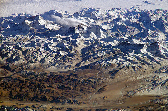
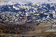
English: Himalaya from the International Space Station. In addition to looking heavenward, NASA helps the world see the Earth in ways no one else can. Astronauts on board the International Space Station recently took advantage of their unique vantage point to photograph the Himalayas, looking south from over the Tibetan Plateau. The perspective is illustrated by the summits of Makalu [left (8,462 metres; 27,765 feet)], Everest [middle (8,848 metres; 29,035 feet)] , Lhotse [middle (8,516 metres; 27,939 feet)] and Cho Oyu [right (8,201 metres; 26,906 feet)] -- at the heights typically flown by commercial aircraft.
Français : L' Himalaya vu de la Station spatiale internationale. La NASA ne fait pas que regarder les étoile, mais utilise aussi ses points de vues uniques pour observer la terre. Cette vue de l'himalaya a été prise depuis la station spatiale internationale, avec le plateau tibétain au premier plan. On peut voir les sommets du Makalu (8 462 mètres, à gauche), de l' Everest (8 848 m, au milieu), du Lhotse (juste a droite de l'Everest, 8516 m) et du Cho Oyu (tout à droite, 8 201 m d'altitude). L'altitude de ces sommets correspond aux altitudes de vol des avions de ligne.
Suomi: Himalaja kansainväliseltä avaruusasemalta kuvattuna
日本語: 国際宇宙ステーションから撮影したヒマラヤ山脈。チベット高原から南方を見た時の図。エベレストが中央付近に見える。
Italiano: L'Himalaya fotografata dalla stazione spaziale internazionale, con l'altopiano del Tibet in primo piano. Si possono notare le cime dei monti Makalu (8462 metri, in alto a sinistra), Everest (8848 metri, in centro), Lhotse (8516 metri, appena sopra l'Everest sulla foto) e Cho Oyu (8201 metri, a destra). Queste altezze corrispondono a quelle raggiunte dagli aerei di linea.
|
|||||
|---|---|---|---|---|---|---|
| Source |
http://www.nasa.gov/multimedia/imagegallery/image_feature_152.html
|
|||||
| Date | ||||||
| Author |
NASA |
|||||
| Permission ( Reusing this image) |
|
|||||
| Other versions |
 |


| |
This image or video was catalogued by one of the centers of the United States National Aeronautics and Space Administration (NASA) under Photo ID: ISS008-E-13304. This tag does not indicate the copyright status or the source of the attached work. A normal copyright tag and a source are still required. See Commons:Licensing for more information. |
| |
This image was selected as a picture of the day for September 16, 2005. It was captioned as followed: English: Himalaya from the International Space Station.
Aragonés: Himalaya dende a Estazión Espazial Internazional.
Brezhoneg: Pladenn Tibet (war an araog) hag an Himalaya gwelet eus ar ( Savlec'h Egorel Etrebroadel (ISS)
Česky: Snímek Himalájí pořízený z Mezinárodní vesmírné stanice.
Cymraeg: Mynyddoedd yr Himalayas, o'r Stesion Gofod Rhwngwladol.
Deutsch: Das Himalaya-Gebirge von der ISS aus
English: Himalaya from the International Space Station.
Suomi: Himalaja kansainväliseltä avaruusasema ISS:ltä kuvattuna
Français : Le plateau du Tibet (premier plan) et l' Himalaya depuis la Station Spatiale Internationale ( ISS)
Galego: O Himalaia dende a Estación Espacial Internacional.
日本語: 国際宇宙ステーションからの ヒマラヤ山脈
Latina: Imaus a Statione Siderali Internationali visus.
Nederlands: Himalaya gezien vanuit het International Space Station.
Norsk (nynorsk): Himalaya sett frå den internasjonale romstasjonen.
Polski: Himalaje widziane z Międzynarodowej Stacji Kosmicznej
Português: Fotografia dos Himalaias a partir da Estação Espacial Internacional.
Русский: Гималаи с борта МКС.
Slovenčina: Záber Himalájí z Mezinárodnej vesmírnej stanice (ISS).
Slovenščina: Pogled na Himalajo z Mednarodne vesoljske postaje (ISS)
ไทย: เทือกเขาหิมาลัยในมุมมองจาก สถานีอวกาศนานาชาติ
中文(简体): 从 国际空间站中看 喜马拉雅山
|
File history
Click on a date/time to view the file as it appeared at that time.
| Date/Time | Dimensions | User | Comment | |
|---|---|---|---|---|
| current | 18:49, 19 February 2005 | 1,000×662 (258 KB) | RedWolf | (Himalaya from the ISS. Photo by NASA.) |
File links
The following pages on Schools Wikipedia link to this image (list may be incomplete):
Categories: Wikipedia featured pictures