Image:Goamap.png
From Wikipedia, the free encyclopedia
Size of this preview: 381 × 479 pixels
Full resolution (795 × 1,000 pixels, file size: 86 KB, MIME type: image/png)
| |
This is a file from the Wikimedia Commons. The description on its description page there is shown below. |
| This is a featured picture, which means that members of the community have identified it as one of the finest images on the English Wikipedia, adding significantly to its accompanying article. If you have a different image of similar quality, be sure to upload it using the proper free license tag, add it to a relevant article, and nominate it. |
| |
This image was selected as picture of the day on the English Wikipedia for October 18, 2005. |
| |
This is a featured picture on English Wikipedia and is considered one of the finest images.
|
|
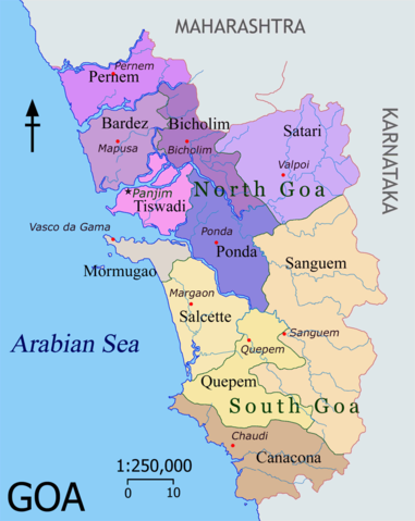
Map of Goa, (an Indian state) featuring depicting their Talukas (district subdivisions) and headquarters.
Colour coding
Goa is divided into two administrative districts: North Goa and South Goa
- Talukas in purple shades belong to North Goa
- Talukas in orange shades belong to South Goa
|

Image made by me. Post a message on my English talk page if you need a translated map. Nichalp 18:29, 31 Mar 2005 (UTC)
 |
This map image should be recreated using vector graphics as an SVG file. This has several advantages; see Commons:Media for cleanup for more information. If an SVG form of this image is already available, please upload it. After uploading an SVG, replace this template with {{ vector version available|new image name.svg}}. |
|
العربية | Български | Català | Česky | Dansk | Deutsch | English | Esperanto | Español | Français | Galego | 한국어 | Italiano | Magyar | Lietuvių | Nederlands | 日本語 | Polski | Português | Română | Русский | Suomi | Svenska | Türkçe | Українська | 中文(繁體) | 中文(简体) | +/- |
|
File history
Click on a date/time to view the file as it appeared at that time.
| Date/Time | Dimensions | User | Comment | |
|---|---|---|---|---|
| current | 18:50, 20 July 2005 | 795×1,000 (86 KB) | Nichalp | (compass direction change) |
| 15:04, 16 July 2005 | 795×1,000 (86 KB) | Nichalp | (Adding scale, removing underline) | |
| 07:24, 13 July 2005 | 795×1,000 (84 KB) | Nichalp | (Higher resolution + optimised) | |
| 18:24, 31 March 2005 | 400×518 (152 KB) | Nichalp | (Improved the colours) | |
| 18:45, 30 March 2005 | 400×518 (190 KB) | Nichalp | (Improved; added capitals) | |
| 18:49, 29 March 2005 | 400×518 (117 KB) | Nichalp | (new goa map {{GFDL}}) |
File links