Image:League of Nations Anachronous Map.PNG
From Wikipedia, the free encyclopedia
Size of this preview: 640 × 407 pixels
Full resolution (1,357 × 863 pixels, file size: 45 KB, MIME type: image/png)
| |
This is a file from the Wikimedia Commons. The description on its description page there is shown below. |
Description
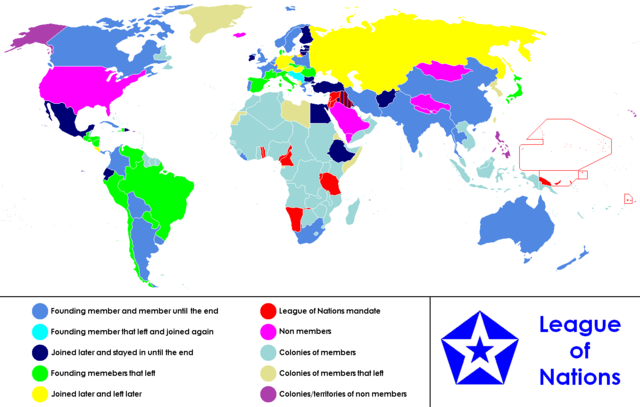
| Description |
Anachronous map of the world between 1920 and 1945 which shows the The League of Nations and the world. / Carte du monde entre 1920 et 1945 montrant la place de la Société des Nations |
|---|---|
| Source | |
| Date |
26 January 2007 |
| Author |
Allard Postman, The Netherlands |
| Permission ( Reusing this image) |
see below
|
Licensing
 |
Permission is granted to copy, distribute and/or modify this document under the terms of the GNU Free Documentation License, Version 1.2 or any later version published by the Free Software Foundation; with no Invariant Sections, no Front-Cover Texts, and no Back-Cover Texts. Subject to disclaimers. Asturianu | Български | Català | Deutsch | English | Español | Français | Gaeilge | Italiano | Polski | Português | +/- |
 |
This map image should be recreated using vector graphics as an SVG file. This has several advantages; see Commons:Media for cleanup for more information. If an SVG form of this image is already available, please upload it. After uploading an SVG, replace this template with {{ vector version available|new image name.svg}}. |
|
العربية | Български | Català | Česky | Dansk | Deutsch | English | Esperanto | Español | Français | Galego | 한국어 | Italiano | Magyar | Lietuvių | Nederlands | 日本語 | Polski | Português | Română | Русский | Suomi | Svenska | Türkçe | Українська | 中文(繁體) | 中文(简体) | +/- |
|
 |
This image (or all images in this category) uses inside labels or attached captions in a specific script or language and might be converted to a language neutral form. This would allow its use in all Wikimedia projects and, more importantly, all Wikimedia languages. Deutsch | Nederlands | English | Español | Français | Italiano | 日本語 | 한국어 | Português | Slovenčina | Српски / Srpski | +/- |
File history
Click on a date/time to view the file as it appeared at that time.
| Date/Time | Dimensions | User | Comment | |
|---|---|---|---|---|
| current | 15:30, 23 April 2008 | 1,357×863 (45 KB) | Haukurth | (Iceland was not a colony, it just wasn't a member. It chose not to join even though that League confirmed that it could.) |
| 03:33, 15 November 2007 | 1,357×863 (48 KB) | Kelvinc | (Korea and Taiwan re-coloured as colony of left member (Japan)) | |
| 18:05, 4 August 2007 | 1,357×863 (70 KB) | Sylfide | ({{Information |Description=Anachronous map of the world between 1920-1944 which shows the The League of Nations and the world. / ''Carte du monde entre 1924 et 1944 montrant la place de la Société des Nations'' |Source=:en:Image:League_of_Nations_Anachr) |