Image:Form of government parliamentary.png
From Wikipedia, the free encyclopedia
Size of this preview: 640 × 296 pixels
Full resolution (1,357 × 628 pixels, file size: 61 KB, MIME type: image/png)
| |
This is a file from the Wikimedia Commons. The description on its description page there is shown below. |
Summary
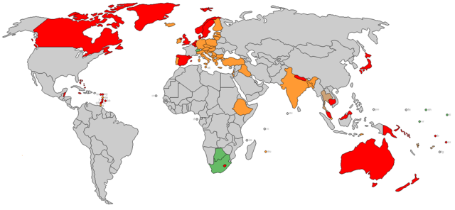
| Description |
World's parliamentary states coloured by form of government as of 2006 |
|---|---|
| Source |
own work, from existing wikimedia blank world map, simplified version of Image:Form of government.png |
| Date |
2 May 2006 |
| Author |
The_Tom |
| Permission ( Reusing this image) |
GFDL
|
Licensing
|

File history
Click on a date/time to view the file as it appeared at that time.
| Date/Time | Dimensions | User | Comment | |
|---|---|---|---|---|
| current | 14:50, 18 September 2007 | 1,357×628 (61 KB) | Glentamara | (Portugal) |
| 23:39, 4 January 2007 | 1,357×628 (21 KB) | The Tom | (Standardized basemap and shading, transparency, microstate labels) | |
| 12:17, 9 August 2006 | 1,357×628 (53 KB) | Satesclop | ||
| 12:04, 9 August 2006 | 1,357×628 (53 KB) | Satesclop | ||
| 04:34, 22 May 2006 | 1,357×628 (53 KB) | The Tom | (revision to Botswana, Finland, Nepal and Serbia-Montenegro) | |
| 16:51, 9 May 2006 | 1,357×628 (53 KB) | The Tom | (Switz. to green) | |
| 00:23, 9 May 2006 | 1,357×628 (53 KB) | The Tom | (New base map with black outlines and enlarged microstates. New pale green for South Africa and 3 South Pacific nations. -~~~~) | |
| 13:37, 2 May 2006 | 1,357×628 (53 KB) | The Tom | ({{Information| |Description=World's parliamentary states coloured by form of government as of 2006 |Source=own work, from existing wikimedia blank world map, simplified version of Image:Form of government.png |Date=2 May 2006 |Author=The_Tom |Permiss) |