Image:Delhi area locator map.svg
From Wikipedia, the free encyclopedia
Delhi_area_locator_map.svg (SVG file, nominally 1,430 × 1,245 pixels, file size: 388 KB)
| |
This is a file from the Wikimedia Commons. The description on its description page there is shown below. |
| WikiProject India Maps |
Delhi locator map |
||
|---|---|---|---|
| Description |
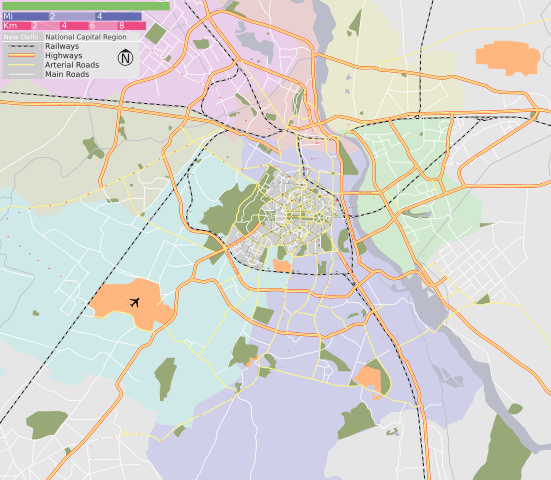
Map of New Delhi and Delhi district, with major roads, railways and water bodies. |
||
| Source |
Delhi Metro |
||
| Date |
3 Mar 07 |
||
| Author |
|
||
| Permission |
GFDL / Creative Commons - Share Alike |
SVG Support
This document is in the Scalable Vector Graphic format (SVG) and requires a supported browser (Opera 9, Firefox 2) or a SVG plugin for Internet Explorer and other browsers. SVG is an open source format, which means this map can be downloaded and modified/translated completely using a vector graphics editor like Adobe Illustrator or Inkscape (free) or a text editor such as Notepad.
| BLANK THUMBNAIL | View large PNG | View medium PNG | SVG Plugin for Internet Explorer and other browsers |
|---|---|---|---|
| Click here (purge cache) and then CTRL+F5 to reload. Help? | Try 1 Try 2 | Try 1 Try 2 | Adobe SVG plugin |
| Recommended browser | More Help | ||
| Opera 9.1 | List of SVG tools |
License
|

Errata
If you notice a mistake on the map, please list them here. Please mention the name of the map to be corrected also.
 |
Textual information once visible in the image itself has been moved into the image metadata and/or image description page. This makes the image easier to reuse and more language-neutral, and makes the text easier to process and search for. Commons discourages placing visible textual information in images. All licenses accepted on Commons permit this type of modification as a derivative work. If attribution information was removed and the image is not public domain, replace this tag with {{ attribution metadata from licensed image}}. Deutsch | English | Français | Italiano | Português | +/- |
File history
Click on a date/time to view the file as it appeared at that time.
| Date/Time | Dimensions | User | Comment | |
|---|---|---|---|---|
| current | 16:06, 7 August 2008 | 1,430×1,245 (388 KB) | Jarekt | ({{Information |Description=removed watermark |Source= |Date= |Author= |Permission= |other_versions= }} ) |
| 10:12, 12 March 2007 | 1,430×1,245 (389 KB) | PlaneMad | ||
| 13:19, 9 March 2007 | 1,552×1,341 (371 KB) | PlaneMad | ||
| 17:59, 3 March 2007 | 1,476×1,274 (227 KB) | PlaneMad | ({{WikiProject India City Maps |Title=Delhi locator map |Description=Map of New Delhi and Delhi district, with major roads, railways and water bodies. |Source= Google maps |Date=3 Mar 07 |Author= w:user:Planemad }}) |