Image:Territories of Dynasties in China.gif
From Wikipedia, the free encyclopedia
Size of this preview: 496 × 479 pixels
Full resolution (556 × 537 pixels, file size: 1.01 MB, MIME type: image/gif)
==Summary== (The picture above cycles so spend your time carefully.)
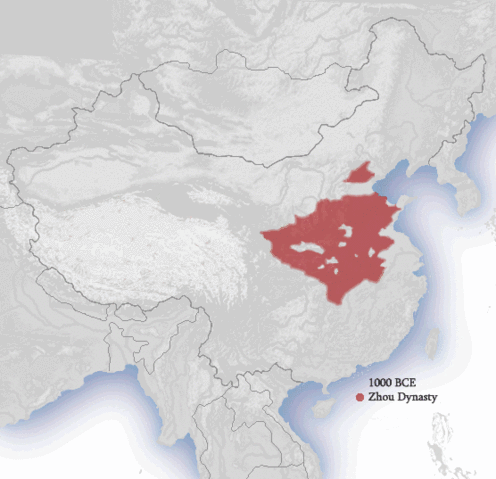
| Description |
The approximate territories of dynasties in China. Drawn by Ian Kiu. Derived from China_map.png by Nat.
|
|---|---|
| Source |
Zhou Dynasty 1000 BCE from "The Chou Dynasty, 11th-9th Centuries B.C." |
| Date |
September 27, 2007 |
| Author |
Ian Kiu |
| Permission ( Reusing this image) |
See below. |
Licensing
| |
I, the copyright holder of this work, hereby grant the permission to copy, distribute and/or modify this document under the terms of the GNU Free Documentation License, Version 1.2 or any later version published by the Free Software Foundation; with no Invariant Sections, no Front-Cover Texts, and no Back-Cover Texts. |
|
|
The Wikimedia Commons has another file with the same name as this file. To include the Commons media file in Wikipedia, this locally stored file needs to be renamed. | |
File history
Click on a date/time to view the file as it appeared at that time.
| Date/Time | Dimensions | User | Comment | |
|---|---|---|---|---|
| current | 11:00, 3 December 2007 | 556×537 (1.01 MB) | Pojanji ( Talk | contribs) | |
| revert | 10:07, 17 November 2007 | 556×537 (274 KB) | Pojanji ( Talk | contribs) | |
| revert | 12:37, 6 November 2007 | 556×537 (279 KB) | Pojanji ( Talk | contribs) | (Additional dynasties. Coast quality. Clear text.) |
| revert | 20:48, 15 October 2007 | 556×537 (300 KB) | Pojanji ( Talk | contribs) | (rm 1912) |
| revert | 04:24, 13 October 2007 | 556×537 (316 KB) | Pojanji ( Talk | contribs) | (Sacrificed transition for sizing, Mordern pollitical entities, Vietnamese border, 2.8 Delay) |
| revert | 22:24, 12 October 2007 | 556×537 (954 KB) | Pojanji ( Talk | contribs) | (Terrain! Coastline! 2 Sec delay, bordering) |
| revert | 11:00, 10 October 2007 | 556×537 (395 KB) | Pojanji ( Talk | contribs) | (Jau Dynasty, Saam Gwok, Correct Hon Dynasty, darken Yuen Border, Optimized Colour, Filesize) |
| revert | 23:57, 30 September 2007 | 556×537 (625 KB) | Pojanji ( Talk | contribs) | (Cheui Dynasty, Jin Gwok Period, White Sea, Delay 3 sec) |
| revert | 03:46, 30 September 2007 | 556×537 (351 KB) | Pojanji ( Talk | contribs) | (Tong Correction) |
| revert | 01:44, 28 September 2007 | 556×537 (346 KB) | Pojanji ( Talk | contribs) | (Ver. 3: Extended Map and labelled dynasty names) |
| revert | 01:20, 26 September 2007 | 560×550 (93 KB) | Pojanji ( Talk | contribs) | (Mod 1.8 Sec Delay) |
| revert | 01:14, 26 September 2007 | 560×550 (93 KB) | Pojanji ( Talk | contribs) | (The approximate territories of dynasties in China. Drawn by Ian Kiu.) |
See the setup instructions for more information.