Image:Western Europe Utrecht Treaty.jpg
From Wikipedia, the free encyclopedia
Size of this preview: 601 × 479 pixels
Full resolution (1,576 × 1,257 pixels, file size: 388 KB, MIME type: image/jpeg)
| |
This is a file from the Wikimedia Commons. The description on its description page there is shown below. |
Beschreibung
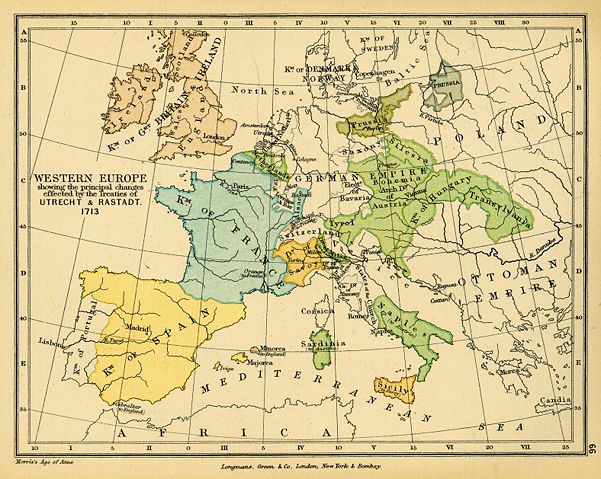
- Beschreibung: Landkarte Europa 1713 nach dem Frieden von Utrecht
- Quelle: http://www.lib.utexas.edu/maps/historical/colbeck/western_europe_utrecht_treaty.jpg
- Urheber: "The Public Schools Historical Atlas" by Charles Colbeck. Longmans, Green; New York; London; Bombay. 1905
- Datum: 1905
- Genehmigung: "Materials that are in the public domain (such as images from the Portrait Gallery or most of the maps in the PCL Map Collection), are not copyrighted and no permission is needed to copy them. You may download them and use them as you wish." "Courtesy of the University of Texas Libraries, The University of Texas at Austin." Quelle: http://www.lib.utexas.edu/usage_statement.html?maps=yes
Licensing
 |
This image (or other media file) is in the public domain because its copyright has expired. This applies to the United States, Canada, the European Union and those countries with a copyright term of life of the author plus 70 years. العربية | Asturianu | Български | Català | Česky | Dansk | Deutsch | English | Ελληνικά | Esperanto | Español | Euskara | فارسی | Français | Gaeilge | Galego | עברית | हिन्दी | Bahasa Indonesia | Italiano | 日本語 | 한국어 | Kurdî / كوردی | Lietuvių | Magyar | Nederlands | Norsk (nynorsk) | Македонски | Bahasa Melayu | Polski | Português | Română | Русский | Slovenčina | Slovenščina | Shqip | Suomi | Sámegiella | Türkçe | 中文(简体) | 中文(繁體) | 粵語 | +/- |
File history
Click on a date/time to view the file as it appeared at that time.
| Date/Time | Dimensions | User | Comment | |
|---|---|---|---|---|
| current | 16:38, 24 November 2006 | 1,576×1,257 (388 KB) | Louis le Grand | ({{Information |Beschreibung= Landkarte Europa 1713 nach dem Frieden von Utrecht |Quelle= http://www.lib.utexas.edu/maps/historical/colbeck/western_europe_utrecht_treaty.jpg |Urheber= "The Public Schools Historical Atlas" by Charles Colbeck. Longmans, Gree) |
File links
Metadata
This file contains additional information, probably added from the digital camera or scanner used to create or digitize it. If the file has been modified from its original state, some details may not fully reflect the modified file.
| Orientation | Normal |
|---|---|
| Horizontal resolution | 300 dpi |
| Vertical resolution | 300 dpi |
| Software used | Adobe Photoshop 7.0 |
| File change date and time | 14:04, 9 December 2003 |
| Colour space | 65535 |