Image:Nagorno-Karabakh Occupation Map.jpg
From Wikipedia, the free encyclopedia
Size of this preview: 640 × 320 pixels
Full resolution (1,000 × 500 pixels, file size: 235 KB, MIME type: image/jpeg)
| |
This is a file from the Wikimedia Commons. The description on its description page there is shown below. |
 |
This map has been uploaded by Electionworld from en.wikipedia.org to enable the |
Summary
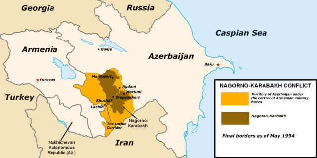
Created by Clevelander using Azerbaijan districts numbered.png, ArmeniaNumbered.png, Gg-map.png, and Iran map.png.
 |
This map image should be recreated using vector graphics as an SVG file. This has several advantages; see Commons:Media for cleanup for more information. If an SVG form of this image is already available, please upload it. After uploading an SVG, replace this template with {{ vector version available|new image name.svg}}. |
|
العربية | Български | Català | Česky | Dansk | Deutsch | English | Esperanto | Español | Français | Galego | 한국어 | Italiano | Magyar | Lietuvių | Nederlands | 日本語 | Polski | Português | Română | Русский | Suomi | Svenska | Türkçe | Українська | 中文(繁體) | 中文(简体) | +/- |
|
Licensing
 |
This image has been released into the public domain by its author, Clevelander. This applies worldwide. In some countries this may not be legally possible; if so: العربية | Български | Deutsch | Ελληνικά | English | Español | Français | Italiano | 日本語 | 한국어 | Polski | Русский | Српски / Srpski | Svenska | தமிழ் | Українська | 中文(繁體) | 中文(简体) +/- |
File history
Click on a date/time to view the file as it appeared at that time.
| Date/Time | Dimensions | User | Comment | |
|---|---|---|---|---|
| current | 20:16, 19 December 2006 | 1,000×500 (235 KB) | Electionworld | ({{ew|en|Clevelander}} == Summary == Created by Clevelander using Azerbaijan districts numbered.png, ArmeniaNumbered.png, Gg-map.png, and [[:Image:Iran map.pn) |
File links
Metadata
This file contains additional information, probably added from the digital camera or scanner used to create or digitize it. If the file has been modified from its original state, some details may not fully reflect the modified file.
| Orientation | Normal |
|---|---|
| Horizontal resolution | 72.009 dpi |
| Vertical resolution | 72.009 dpi |
| Software used | Adobe Photoshop CS2 Windows |
| File change date and time | 16:15, 19 July 2006 |
| Colour space | 65535 |