Image:Zambezi Barotse floodplain.jpg
From Wikipedia, the free encyclopedia
Size of this preview: 271 × 479 pixels
Full resolution (396 × 700 pixels, file size: 61 KB, MIME type: image/jpeg)
| |
This is a file from the Wikimedia Commons. The description on its description page there is shown below. |
Summary
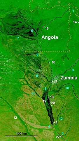
| Description |
NASA false-colour image of the upper Zambezi and Barotse (Balozi) floodplain in extreme flood in 2003, water shows as dark areas. Blue numbers are rivers: 1 Zambezi source, 2 Zambezi at Chavuma Falls, 3 at start of Barotse Floodplain, 4 at end of the floodplain at the Kalongola Ferry, 5 at Ngonye Falls. Tributaries: 6 Chifumage, 7 Luena, 8 Lungwebungu, 9 Kabompo, 10 Luampa, 11 Luanguinga, 12 Lui, 13 Cuando. Towns (white numbers): 14 Mwinilunga, 15 Cazombo, 16 Zambezi, 17 Lukulu, 18 Limulunga, 19 Lealui, 20 Mongu, 21 Senanga, 22 Sioma.. |
|---|---|
| Source |
Base is NASA image in public domain NASA: "Visible Earth" website accessed 1 March 2007 Credit: Jacques Descloitres, MODIS Rapid Response Team, NASA/GSFC. |
| Date |
15 March 2007 |
| Author |
Rexparry_Sydney added overlay of labels/Symbols |
| Permission ( Reusing this image) |
See NASA terms of use on website above
|
Licensing
|

File history
Click on a date/time to view the file as it appeared at that time.
| Date/Time | Dimensions | User | Comment | |
|---|---|---|---|---|
| current | 12:30, 16 March 2007 | 396×700 (61 KB) | Rexparry sydney | ({{Information |Description=NASA false-colour image of the upper Zambezi and Barotse (Balozi) floodplain in extreme flood in 2003, water shows as dark areas. For caption explaining numbered landmarks see Wikipedia:Zambezi River. |Source=Base is NASA im) |