Image:The world in 500 CE.PNG
From Wikipedia, the free encyclopedia
Size of this preview: 640 × 326 pixels
Full resolution (4,000 × 2,036 pixels, file size: 1.72 MB, MIME type: image/png)
| |
This is a file from the Wikimedia Commons. The description on its description page there is shown below. |
| Description |
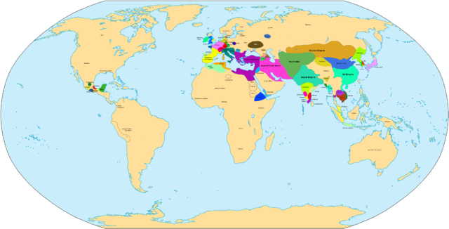
Main states in 500 CE |
|---|---|
| Source |
self-made |
| Date |
may 20 2007 |
| Author |
Javierfv1212 |
| Permission ( Reusing this image) |
see below
|
| Maps of world history | |
| BC |
2000 · 1500 · 1000 · 500 · 400 · 323 · 300 · 200 · 100 · 50 |
|
|
|
| AD |
1 · 50 · 100 · 200 · 250 · 300 · 400 · 450 · 500 · 600 · 700 · 750 · 800 · 820 · 900 · 1000 · 1300 · 1492 · 1550 · 1660 · 1754 · 1822 · 1885 · 1898 · 1914 · 1920 · 1936 · 1938 · 1945 · 1959 · 1959 · 1974 · 1980 · 2007 |
| (this template: · view · discuss ) | |
|
File history
Click on a date/time to view the file as it appeared at that time.
| Date/Time | Dimensions | User | Comment | |
|---|---|---|---|---|
| current | 21:25, 20 May 2007 | 4,000×2,036 (1.72 MB) | Javierfv1212 | ({{Information |Description=Main states in 500 CE |Source=self-made |Date=may 20 2007 |Author= User:Javierfv1212 }} Category:Maps of the world showing history) |
File links
The following pages on Schools Wikipedia link to this image (list may be incomplete):