Image:Southern Italy 1112.svg
From Wikipedia, the free encyclopedia
Southern_Italy_1112.svg (SVG file, nominally 712 × 807 pixels, file size: 652 KB)
| |
This is a file from the Wikimedia Commons. The description on its description page there is shown below. |
Contents |
Summary
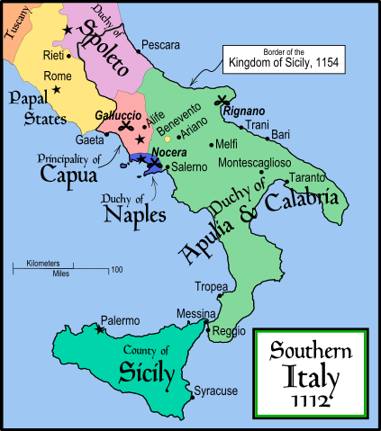
This is a political map of southern Italy in 1112 AD/ CE, the date when Roger II of Sicily reached his age of majority, also showing the border of the Kingdom of Sicily in 1154, on his death.
"The rarity of surviving records makes it impossible to draw a map of comital [counts'] responsibiities in southern Italy at the beginning of the twelth century." Matthew, p. 23.
As noted by Matthew, the political situation in southern Italy is much more complex than this map shows. There were numerous counts and semi-independent cities throughout the region. Moreover, the near-constant rebellions and conquests continually re-arranged the map.
References
- Bjorklund, Oddvar; Holmboe, Haakon; Rohr, Anders (1970) Historical Atlas of the World, Barnes & Noble, NY, SBN: 389-00253-4.
- Houben, Hubert (translated by Graham A. Loud and Diane Milburn), (2002) Roger II of Sicily: Ruler between East and West, Cambridge University Press.
- Konstam, Angus (2000) Atlas of Medieval Europe, Checkmark Books, New York.
- Matthew, Donald (1992) The Norman Kingdom of Sicily Cambridge Medieval Textbooks.
Other versions
Licensing
|

File history
Click on a date/time to view the file as it appeared at that time.
| Date/Time | Dimensions | User | Comment | |
|---|---|---|---|---|
| current | 17:29, 9 January 2008 | 712×807 (652 KB) | Salli | |
| 21:12, 16 April 2007 | 712×807 (739 KB) | MapMaster | (Slightly modified version) | |
| 16:32, 20 December 2006 | 712×807 (739 KB) | MapMaster | (Fixed typo, added Taranto) | |
| 14:15, 16 December 2006 | 712×807 (729 KB) | MapMaster | (A political map of southern Italy in 1112 AD/ CE, the date when Roger II of Sicily reached his age of majority.) |