Image:Beeching2.svg
From Wikipedia, the free encyclopedia
Beeching2.svg (SVG file, nominally 1,480 × 2,436 pixels, file size: 182 KB)
| |
This is a file from the Wikimedia Commons. The description on its description page there is shown below. |
Summary
| Description |
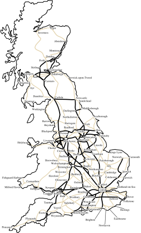
This is what the BR network could have looked like, by the 1980s, had the Beeching II developments had gone ahead. All lines except those shown in bold would have been closed. Some parts of the country - Wales and North & West Scotland- would have had no lines. However the plans were quietly shelved, and closures slowed. Beeching resigned. Notes: 1. Some suburban lines around certain cities (eg. London, Birmingham, Glasgow, Manchester) would have been kept open for commuters- this is not acknowledged on the map. 2. It is interesting that the Woodhead route (Manchester to Sheffield) is shown to be kept open on this map, but was axed in the 1980s. 3. The lines in faint are examples of major through routes that would have closed. Most of these remain open to this day, although some were axed subsequently. |
|---|---|
| Source |
self-made, based on an a poster from Beeching II report. |
| Date |
2007 |
| Author |
Was done on behalf of the Wikipedia User:Btline (original image up-loader) by Cronholm144 via the Wikipeida Graphic Lab |
| Permission ( Reusing this image) |
see below |
| Other versions | Image:Beeching2_clear.svg/ |
Licensing
|

File history
Click on a date/time to view the file as it appeared at that time.
| Date/Time | Dimensions | User | Comment | |
|---|---|---|---|---|
| current | 12:24, 13 July 2007 | 1,480×2,436 (182 KB) | Time3000 | (Fix island obscuring text) |
| 12:21, 13 July 2007 | 1,480×2,436 (182 KB) | Time3000 | (Include islands (e.g. Isle of Mann) and fix typo) | |
| 20:50, 10 July 2007 | 1,444×2,436 (198 KB) | Cronholm144 | (tweak) | |
| 01:22, 10 July 2007 | 1,444×2,436 (198 KB) | Cronholm144 | (cities) | |
| 02:09, 9 July 2007 | 1,284×2,436 (114 KB) | Cronholm144 | ({{Information |Description=map o' Britain |Source=self-made |Date= |Author= Cronholm144 }} ) |