Image:Apdx F2 - Aerial photo after explosion.jpg
From Wikipedia, the free encyclopedia
Size of this preview: 600 × 479 pixels
Full resolution (686 × 548 pixels, file size: 19 KB, MIME type: image/jpeg)
Summary
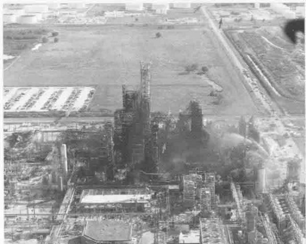
Aerial photo of complex as seen from north to south. Dark arrow at top points to the north edge of the staging area for responding mutual aid equipment. Area of origin thought to be near centre (light arrow).
Appendix F1. Aerial photo of complex as seen from north to south, from page 89 of http://ncsp.tamu.edu/reports/USFA/pasadena.pdf . This is a document is under the auspices of the United States Fire Administration, Technical Report Series, entitled "Phillips Petroleum Chemical Plant Explosion and Fire -- Pasadena, Texas" from the Federal Emergency Management Agency, United States Fire Administration, National Fire Data Centre.
Licensing
 |
This work is in the public domain in the United States because it is a work of the United States Federal Government under the terms of Title 17, Chapter 1, Section 105 of the US Code. See Copyright. Note: This only applies to works of the Federal Government and not to the work of any individual U.S. state, territory, commonwealth, county, municipality, or any other subdivision. This template also does not apply to postage stamps published by the United States Postal Service. (See 206.02(b) of Compendium II: Copyright Office Practices). |
 |
File history
Click on a date/time to view the file as it appeared at that time.
| Date/Time | Dimensions | User | Comment | |
|---|---|---|---|---|
| current | 03:51, 7 December 2007 | 686×548 (19 KB) | Arthur Smart ( Talk | contribs) | (Appendix F1. Aerial photo of complex as seen from north to south, from page 89 of http://ncsp.tamu.edu/reports/USFA/pasadena.pdf . This is a document is under the auspices of the United States Fire Administration, Technical Report Series, entitled "Phil) |
See the setup instructions for more information.