Image:Panama-Canal-rough-diagram-quick.jpg
From Wikipedia, the free encyclopedia
Size of this preview: 497 × 479 pixels
Full resolution (560 × 540 pixels, file size: 57 KB, MIME type: image/jpeg)
| |
This is a file from the Wikimedia Commons. The description on its description page there is shown below. |
Summary
| Description |
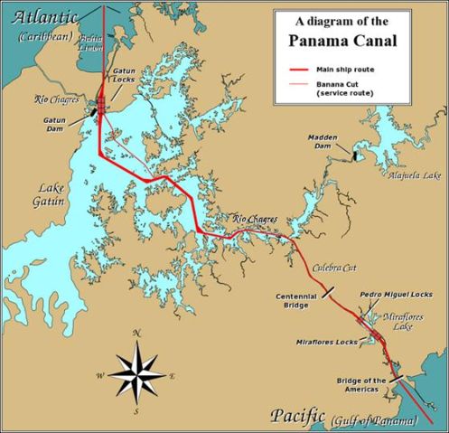
English: A diagram illustrating the layout of the Panama Canal (in quick JPEG format, auto-resizes to fit).
Due to the shape of the Isthmus of Panama, the Pacific end of the canal is actually the south-east end, and the Caribbean / Atlantic end is at the north-west. From the Pacific side, the Miraflores and Pedro Miguel locks (with two and one stages respectively) lead up to the highest level of the canal, 26 metres (85 feet) above sea level. The Culebra Cut (or Gaillard Cut) leads to Gatún Lake, created by damming the Chagres River; then the Gatún Locks lead back down to sea level in Limón Bay. The heavy red line shows the ship route. The narrower red line in Gatún Lake is the Banana Cut, a shortcut used by canal boats and yachts. |
|---|---|
| Source |
Source URL: Image:Panama_Canal_Rough_Diagram.png ( GFDL file, reduced/retouched, saved JPEG format (5x faster than PNG), intended for use in frequently-read Wiki articles). |
| Date |
26-December-2006 |
| Author |
User:Johantheghost (JPEG version by Wikid77) |
| Permission ( Reusing this image) |
(see below)
|
 |
This map image should be recreated using vector graphics as an SVG file. This has several advantages; see Commons:Media for cleanup for more information. If an SVG form of this image is already available, please upload it. After uploading an SVG, replace this template with {{ vector version available|new image name.svg}}. |
|
العربية | Български | Català | Česky | Dansk | Deutsch | English | Esperanto | Español | Français | Galego | 한국어 | Italiano | Magyar | Lietuvių | Nederlands | 日本語 | Polski | Português | Română | Русский | Suomi | Svenska | Türkçe | Українська | 中文(繁體) | 中文(简体) | +/- |
|
Licensing
 |
Permission is granted to copy, distribute and/or modify this document under the terms of the GNU Free Documentation license, Version 1.2 or any later version published by the Free Software Foundation; with no Invariant Sections, no Front-Cover Texts, and no Back-Cover Texts. A copy of the license is included in the section entitled " GNU Free Documentation license". Aragonés | العربية | Asturianu | Беларуская (тарашкевіца) | Български | বাংলা | ইমার ঠার/বিষ্ণুপ্রিয়া মণিপুরী | Brezhoneg | Bosanski | Català | Cebuano | Česky | Dansk | Deutsch | Ελληνικά | English | Esperanto | Español | Eesti | Euskara | فارسی | Suomi | Français | Gaeilge | Galego | עברית | Hrvatski | Magyar | Bahasa Indonesia | Ido | Íslenska | Italiano | 日本語 | ქართული | ភាសាខ្មែរ | 한국어 | Kurdî / كوردی | Latina | Lëtzebuergesch | Lietuvių | Bahasa Melayu | Nnapulitano | Nederlands | Norsk (nynorsk) | Norsk (bokmål) | Occitan | Polski | Português | Română | Русский | Slovenčina | Slovenščina | Shqip | Српски / Srpski | Svenska | తెలుగు | ไทย | Tagalog | Türkçe | Українська | اردو | Tiếng Việt | Volapük | Yorùbá | 中文(简体) | 中文(繁體) | +/- |
File history
Click on a date/time to view the file as it appeared at that time.
| Date/Time | Dimensions | User | Comment | |
|---|---|---|---|---|
| current | 17:28, 26 December 2006 | 560×540 (57 KB) | Wikid77 | (== Summary == A diagram illustrating the layout of the Panama Canal (in quick JPEG format, auto-resizes to fit). Due to the shape of the Isthmus of Panama, the Pacific) |