Image:Greenland big.png
From Wikipedia, the free encyclopedia
Size of this preview: 294 × 479 pixels
Full resolution (492 × 802 pixels, file size: 40 KB, MIME type: image/png)
| |
This map image was uploaded in a raster image format such as PNG, GIF, or JPEG. However, it contains information that could be stored more efficiently and/or accurately in the SVG format, as a vector graphic. If possible, please upload an SVG version of this image. After doing so, please replace all instances of the previous version throughout Wikipedia (noted under the “File links” header), tag the old version with {{ Vector version available|NewImage.svg}}, and remove this tag. For more information, see Wikipedia:Preparing images for upload. For assistance with converting to SVG, please see the Graphics Lab. |
 |
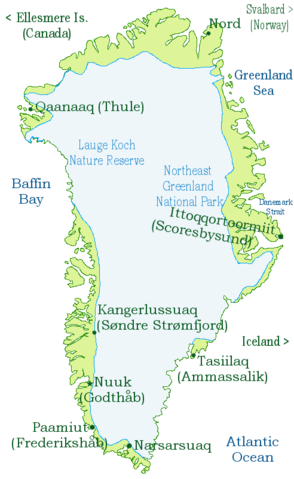
Greenland map, based on a CIA map.
| |
Permission is granted to copy, distribute and/or modify this document under the terms of the GNU Free Documentation License, Version 1.2 or any later version published by the Free Software Foundation; with no Invariant Sections, no Front-Cover Texts, and no Back-Cover Texts. Subject to disclaimers. |
|
|
The Wikimedia Commons has another file with the same name as this file. To include the Commons media file in Wikipedia, this locally stored file needs to be renamed. | |
File history
Click on a date/time to view the file as it appeared at that time.
| Date/Time | Dimensions | User | Comment | |
|---|---|---|---|---|
| current | 20:43, 3 March 2007 | 492×802 (40 KB) | Tene ( Talk | contribs) | (Optimised (0)) |
| revert | 22:21, 2 March 2003 | 492×802 (66 KB) | Menchi ( Talk | contribs) | (+ accents) |
| revert | 21:55, 2 March 2003 | 492×802 (65 KB) | Menchi ( Talk | contribs) | (Greenland map (big), based on CIA map) |
See the setup instructions for more information.
File links
The following pages on Schools Wikipedia link to this image (list may be incomplete):
Categories: Map images that should be in SVG format | Maps of Greenland