From Wikipedia, the free encyclopedia
 Size of this preview: 355 × 479 pixels
 Full resolution (1,330 × 1,794 pixels, file size: 1.34 MB, MIME type: image/png)
 |
This is a file from the Wikimedia Commons. The description on its description page there is shown below.Commons is a freely licensed media file repository. You can help.
|
Summary
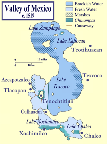
This is a map of the Valley of Mexico on the eve of the Spanish conquest of Mexico. It shows the major towns within the Valley, in particular, the island capital of the Aztecs, Tenochtitlan.
The map also shows the five lakes that once existed within the Valley, highlighted to differentiate the brackish from the fresh waters.
It was compiled from several sources, most prominently those listed below. . .
References
- Coe, Michael; Snow, Dean; Benson, Elizabeth; Atlas of Ancient America; Facts on File, New York, 1986.
- Townsend, Richard F.; Aztecs; Thames & Hudson, London, 1992.
Licensing
I, the copyright holder of this work, hereby publish it under the following licenses:
 |
Permission is granted to copy, distribute and/or modify this document under the terms of the GNU Free Documentation license, Version 1.2 or any later version published by the Free Software Foundation; with no Invariant Sections, no Front-Cover Texts, and no Back-Cover Texts. A copy of the license is included in the section entitled " GNU Free Documentation license".
Aragonés | العربية | Asturianu | Беларуская (тарашкевіца) | Български | বাংলা | ইমার ঠার/বিষ্ণুপ্রিয়া মণিপুরী | Brezhoneg | Bosanski | Català | Cebuano | Česky | Dansk | Deutsch | Ελληνικά | English | Esperanto | Español | Eesti | Euskara | فارسی | Suomi | Français | Gaeilge | Galego | עברית | Hrvatski | Magyar | Bahasa Indonesia | Ido | Íslenska | Italiano | 日本語 | ქართული | ភាសាខ្មែរ | 한국어 | Kurdî / كوردی | Latina | Lëtzebuergesch | Lietuvių | Bahasa Melayu | Nnapulitano | Nederlands | Norsk (nynorsk) | Norsk (bokmål) | Occitan | Polski | Português | Română | Русский | Slovenčina | Slovenščina | Shqip | Српски / Srpski | Svenska | తెలుగు | ไทย | Tagalog | Türkçe | Українська | اردو | Tiếng Việt | Volapük | Yorùbá | 中文(简体) | 中文(繁體) | +/- |
You may select the license of your choice.
|
File history
Click on a date/time to view the file as it appeared at that time.
|
|
Date/Time |
Dimensions |
User |
Comment |
| current |
00:48, 23 February 2007 |
1,330×1,794 (1.34 MB) |
Madman2001 |
|
File links
The following pages on Schools Wikipedia link to this image (list may be incomplete):