Image:Holyromanempire.png
From Wikipedia, the free encyclopedia
Size of this preview: 569 × 480 pixels
Full resolution (687 × 579 pixels, file size: 19 KB, MIME type: image/png)
| |
This is a file from the Wikimedia Commons. The description on its description page there is shown below. |
Summary
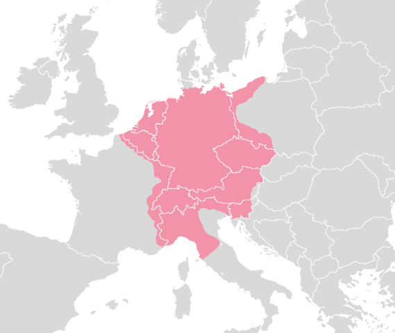
DEUTSCH
Das Heilige Römische Reich Deutscher Nation um 1630
Gebiet, das vom Heiligen Römischen Reich um 1630 kontrolliert wurde mit den Grenzen der modernen Staaten.
Erstellt von; Blank map europe.png.
ENGLISH
The Holy Roman Empire around 1630.
Area controlled by the Holy Roman Empire around 1630 with the visable outlines of modern countries.
Made from; Blank map europe.png.
NEDERLANDS/DUTCH:
Het Heilige Roomse Rijk omstreeks 1630.
Gebied bestuurd door het Heilige Roomse Rijk omstreeks 1630 met de zichtbare grenzen van hedendaagse landen.
Gemaakt van; Blank map europe.png.
Made By:
Rex 16:31, 11 August 2006 (UTC)
Licensing
 |
I, the copyright holder of this work, hereby release it into the public domain. This applies worldwide. In case this is not legally possible: Afrikaans | Alemannisch | Aragonés | العربية | Asturianu | Български | Català | Cebuano | Česky | Cymraeg | Dansk | Deutsch | Eʋegbe | Ελληνικά | English | Español | Esperanto | Euskara | Estremeñu | فارسی | Français | Galego | 한국어 | हिन्दी | Hrvatski | Ido | Bahasa Indonesia | Íslenska | Italiano | עברית | Kurdî / كوردی | Latina | Lietuvių | Latviešu | Magyar | Македонски | Bahasa Melayu | Nederlands | Norsk (bokmål) | Norsk (nynorsk) | 日本語 | Polski | Português | Ripoarisch | Română | Русский | Shqip | Slovenčina | Slovenščina | Српски / Srpski | Suomi | Svenska | ไทย | Tagalog | Türkçe | Українська | Tiếng Việt | Walon | 中文(简体) | 中文(繁體) | zh-yue-hant | +/- |
File history
Click on a date/time to view the file as it appeared at that time.
| Date/Time | Dimensions | User | Comment | |
|---|---|---|---|---|
| current | 01:18, 8 August 2008 | 687×579 (19 KB) | Trinsath | ({{Information |Description= |Source=holyromanempire.png |Date=8. August 2008 |Author= ~~~ |Permission= |other_versions= }}) |
| 13:28, 19 August 2006 | 687×579 (22 KB) | Rex Germanus | (== Summary == '''ENGLISH:''' '''''The Holy Roman Empire around 1630.''''' Area controlled by the Holy Roman Empire around 1630 with the visable outlines of modern countries. <font colour="red">'''Note''':''The Netherlands are portrayed in lighter shade) | |
| 16:13, 11 August 2006 | 687×579 (21 KB) | Rex Germanus | ('''ENGLISH:''' '''''The Holy Roman Empire around 1630.''''' Area controlled by the Holy Roman Empire around 1630 with the visable outlines of modern countries. ''The Netherlands are portrayed in lighter shade of red/pink as they were only formally a par) |