Image:Arable land percent world.png
From Wikipedia, the free encyclopedia
Size of this preview: 640 × 296 pixels
Full resolution (1,357 × 628 pixels, file size: 40 KB, MIME type: image/png)
| |
This is a file from the Wikimedia Commons. The description on its description page there is shown below. |
Summary
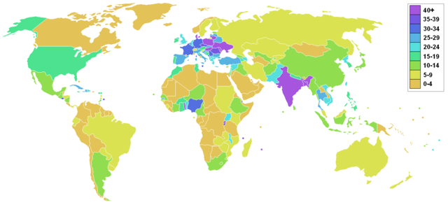
Arable land percentage by country, as listed on CIA factbook, accessed June 2006. Made from blank world map on commons.
Licensing
|

 |
This map image should be recreated using vector graphics as an SVG file. This has several advantages; see Commons:Media for cleanup for more information. If an SVG form of this image is already available, please upload it. After uploading an SVG, replace this template with {{ vector version available|new image name.svg}}. |
|
العربية | Български | Català | Česky | Dansk | Deutsch | English | Esperanto | Español | Français | Galego | 한국어 | Italiano | Magyar | Lietuvių | Nederlands | 日本語 | Polski | Português | Română | Русский | Suomi | Svenska | Türkçe | Українська | 中文(繁體) | 中文(简体) | +/- |
|
File history
Click on a date/time to view the file as it appeared at that time.
| Date/Time | Dimensions | User | Comment | |
|---|---|---|---|---|
| current | 10:01, 27 November 2006 | 1,357×628 (40 KB) | Roke | |
| 04:55, 19 June 2006 | 1,357×628 (53 KB) | Roke | (Arable land percentage by country, as listed on [http://www.cia.gov/cia/publications/factbook/fields/2097.html CIA factbook], accessed June 2006. Category:Demographic world maps) |