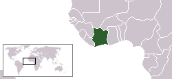
Image:LocationCotedIvoire.png
From Wikipedia, the free encyclopedia
No higher resolution available.
LocationCotedIvoire.png (250 × 115 pixels, file size: 6 KB, MIME type: image/png)
| |
This is a file from the Wikimedia Commons. The description on its description page there is shown below. |
| Description |
English: Location map for the Côte d'Ivoire
|
|---|---|
| Source |
own work |
| Date |
2004-12-12 |
| Author |
Originally created for English Wikipedia by Vardion. |
| Permission ( Reusing this image) |
see below
|
 |
This image has been (or is hereby) released into the public domain by its author, Vardion at the English Wikipedia project. This applies worldwide. In case this is not legally possible: |
 A vector version of this image (SVG) is available. For more information about vector graphics, read about Commons transition to SVG. Deutsch | English | Español | Français | Galego | עברית | Magyar | Italiano | 日本語 | 한국어 | Lietuvių | Polski | Português | Русский | Српски / Srpski | Українська | +/- |
 |
File history
Click on a date/time to view the file as it appeared at that time.
| Date/Time | Dimensions | User | Comment | |
|---|---|---|---|---|
| current | 23:26, 11 December 2004 | 250×115 (6 KB) | EugeneZelenko | (Location map for the Côte d'Ivoire.<br/>Originally created for English Wikipedia by Vardion.<br/>{{PD}}<br/> Category:Country locator maps) |