Image:Lechaeum.png
From Wikipedia, the free encyclopedia

No higher resolution available.
Lechaeum.png (355 × 274 pixels, file size: 62 KB, MIME type: image/png)
| |
This is a file from the Wikimedia Commons. The description on its description page there is shown below. |
Summary
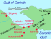
Map of area around ancient Lecaheum, near Corinth. The Corinthian Canal has been erased from the map.
Locations were judged from a variety of sources including maps of University of Chicago excavations and from Planetware.com for the ancient sites.
Other versions
Image:Lechaeum.svg, Image:Lechaeum-es.svg
 A vector version of this image (SVG) is available. For more information about vector graphics, read about Commons transition to SVG. Deutsch | English | Español | Français | Galego | עברית | Magyar | Italiano | 日本語 | 한국어 | Lietuvių | Polski | Português | Русский | Српски / Srpski | Українська | +/- |
 |
Licensing
DEMIS World Map Server generated this map from Public Domain sources. DEMIS does not claim any rights over the resultant image ( ). Addition of towns and captions, and alteration to remove the modern Corinthian Canal, were performed on 13 April 2006 by User:TheGrappler, the uploader, who releases all associated rights.
 |
I, the copyright holder of this work, hereby release it into the public domain. This applies worldwide. In case this is not legally possible: Afrikaans | Alemannisch | Aragonés | العربية | Asturianu | Български | Català | Cebuano | Česky | Cymraeg | Dansk | Deutsch | Eʋegbe | Ελληνικά | English | Español | Esperanto | Euskara | Estremeñu | فارسی | Français | Galego | 한국어 | हिन्दी | Hrvatski | Ido | Bahasa Indonesia | Íslenska | Italiano | עברית | Kurdî / كوردی | Latina | Lietuvių | Latviešu | Magyar | Македонски | Bahasa Melayu | Nederlands | Norsk (bokmål) | Norsk (nynorsk) | 日本語 | Polski | Português | Ripoarisch | Română | Русский | Shqip | Slovenčina | Slovenščina | Српски / Srpski | Suomi | Svenska | ไทย | Tagalog | Türkçe | Українська | Tiếng Việt | Walon | 中文(简体) | 中文(繁體) | zh-yue-hant | +/- |
| |
This image is in the public domain because came from the site http://www.demis.nl/home/pages/Gallery/examples.htm and was released by the copyright holder. Permission is granted to copy, distribute and/or modify this map since it is based on free of copyright images from: www.demis.nl. See also approval email on de.wp and its clarification. |
File history
Click on a date/time to view the file as it appeared at that time.
| Date/Time | Dimensions | User | Comment | |
|---|---|---|---|---|
| current | 00:45, 13 April 2006 | 355×274 (62 KB) | TheGrappler | (Last upload contained error) |
| 00:43, 13 April 2006 | (576 KB) | TheGrappler | (Clearer font) | |
| 00:40, 13 April 2006 | 355×274 (62 KB) | TheGrappler | (Less obtrusive arrow) | |
| 00:32, 13 April 2006 | 355×274 (63 KB) | TheGrappler | (Better captions) | |
| 00:31, 13 April 2006 | 355×274 (63 KB) | TheGrappler | (Re-upload with improved captions) | |
| 18:34, 12 April 2006 | 302×216 (44 KB) | TheGrappler | (De-italicize "Isthmia") | |
| 18:30, 12 April 2006 | 302×216 (44 KB) | TheGrappler | (Map of area around ancient Lechaeum.) |