Image:Elevation flat polar quartic.jpg
From Wikipedia, the free encyclopedia
Size of this preview: 640 × 294 pixels
Full resolution (800 × 368 pixels, file size: 49 KB, MIME type: image/jpeg)
| |
This is a file from the Wikimedia Commons. The description on its description page there is shown below. |
Summary
License information
| |
This file is licensed under Creative Commons Attribution 2.5 License In short: you are free to distribute and modify the file as long as you attribute its author(s) or licensor(s). |
 |
Permission is granted to copy, distribute and/or modify this document under the terms of the GNU Free Documentation license, Version 1.2 or any later version published by the Free Software Foundation; with no Invariant Sections, no Front-Cover Texts, and no Back-Cover Texts. A copy of the license is included in the section entitled " GNU Free Documentation license". Aragonés | العربية | Asturianu | Беларуская (тарашкевіца) | Български | বাংলা | ইমার ঠার/বিষ্ণুপ্রিয়া মণিপুরী | Brezhoneg | Bosanski | Català | Cebuano | Česky | Dansk | Deutsch | Ελληνικά | English | Esperanto | Español | Eesti | Euskara | فارسی | Suomi | Français | Gaeilge | Galego | עברית | Hrvatski | Magyar | Bahasa Indonesia | Ido | Íslenska | Italiano | 日本語 | ქართული | ភាសាខ្មែរ | 한국어 | Kurdî / كوردی | Latina | Lëtzebuergesch | Lietuvių | Bahasa Melayu | Nnapulitano | Nederlands | Norsk (nynorsk) | Norsk (bokmål) | Occitan | Polski | Português | Română | Русский | Slovenčina | Slovenščina | Shqip | Српски / Srpski | Svenska | తెలుగు | ไทย | Tagalog | Türkçe | Українська | اردو | Tiếng Việt | Volapük | Yorùbá | 中文(简体) | 中文(繁體) | +/- |
{{{2}}}
|
|
Original upload log
(All user names refer to en.wikipedia)
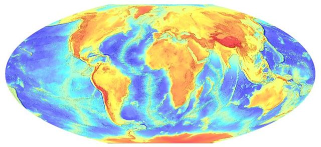
- 2007-01-25 15:32 Wikid77 800×368×8 (49831 bytes) Elevation map of the entire [[Earth]], as a flat polar quartic, with colour-coding to indicate higher elevations as darker brown ([[JPEG]] version). The map is based on the ETOPO2 dataset, distributed by the [[USGS]] in the [[U.S.]]. [[PNG]]-format versi
Licensing
| |
Permission is granted to copy, distribute and/or modify this document under the terms of the GNU Free Documentation License, Version 1.2 or any later version published by the Free Software Foundation; with no Invariant Sections, no Front-Cover Texts, and no Back-Cover Texts. Subject to disclaimers. Asturianu | Български | Català | Deutsch | English | Español | Français | Gaeilge | Italiano | Polski | Português | +/- |
File history
Click on a date/time to view the file as it appeared at that time.
| Date/Time | Dimensions | User | Comment | |
|---|---|---|---|---|
| current | 02:24, 28 February 2007 | 800×368 (49 KB) | Dronemvp | ({{Information |Description=Elevation map of the entire en:Earth, as a flat polar quartic, with colour-coding to indicate higher elevations as darker brown ( en:JPEG version). The map is based on the ETOPO2 dataset, distributed by the en:USGS) |