Image:Greater london outline map bw.png
From Wikipedia, the free encyclopedia
Size of this preview: 576 × 480 pixels
Full resolution (600 × 500 pixels, file size: 199 KB, MIME type: image/png)
| |
This is a file from the Wikimedia Commons. The description on its description page there is shown below. |
Summary
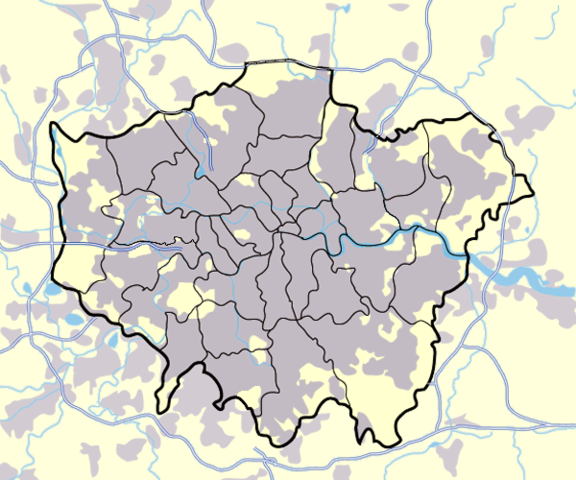
Image:Greater_london_outline_map.png showing built up areas in grey, motorways in blue, water-bodies in light-blue and London borough and county boundaries in black.
Based on a map originally by User:ChrisO.
Revised to correct motorways. DavidCane 19:42, 31 March 2007 (UTC)
Licensing
 |
Permission is granted to copy, distribute and/or modify this document under the terms of the GNU Free Documentation license, Version 1.2 or any later version published by the Free Software Foundation; with no Invariant Sections, no Front-Cover Texts, and no Back-Cover Texts. A copy of the license is included in the section entitled " GNU Free Documentation license". Aragonés | العربية | Asturianu | Беларуская (тарашкевіца) | Български | বাংলা | ইমার ঠার/বিষ্ণুপ্রিয়া মণিপুরী | Brezhoneg | Bosanski | Català | Cebuano | Česky | Dansk | Deutsch | Ελληνικά | English | Esperanto | Español | Eesti | Euskara | فارسی | Suomi | Français | Gaeilge | Galego | עברית | Hrvatski | Magyar | Bahasa Indonesia | Ido | Íslenska | Italiano | 日本語 | ქართული | ភាសាខ្មែរ | 한국어 | Kurdî / كوردی | Latina | Lëtzebuergesch | Lietuvių | Bahasa Melayu | Nnapulitano | Nederlands | Norsk (nynorsk) | Norsk (bokmål) | Occitan | Polski | Português | Română | Русский | Slovenčina | Slovenščina | Shqip | Српски / Srpski | Svenska | తెలుగు | ไทย | Tagalog | Türkçe | Українська | اردو | Tiếng Việt | Volapük | Yorùbá | 中文(简体) | 中文(繁體) | +/- |
File history
Click on a date/time to view the file as it appeared at that time.
| Date/Time | Dimensions | User | Comment | |
|---|---|---|---|---|
| current | 17:13, 11 March 2008 | 600×500 (199 KB) | Jhamez84 | (slight alteration making the boundaries clearer between Newham and Barking and Dagenham - Ealing and Hounslow - and City of London and the City of Westminster) |
| 19:40, 31 March 2007 | 600×500 (217 KB) | DavidCane | ||
| 14:33, 19 March 2007 | 600×500 (512 KB) | Jhamez84 | (minor colour correction) | |
| 14:30, 19 March 2007 | 600×500 (512 KB) | Jhamez84 | (yellowed white backdrop and altered blue of water bodies inline with UK mapping) | |
| 11:16, 15 March 2007 | 600×500 (552 KB) | Jhamez84 | (Corrected some issues with Motorways and borough boundaries. ) | |
| 19:22, 25 February 2007 | 600×500 (476 KB) | Jhamez84 | (Map of Greater London and area. Self made and released to public domain.) | |
| 18:09, 18 November 2006 | 600×500 (21 KB) | Dtcdthingy | ( Image:Greater_london_outline_map.png with toned down colour scheme. Originally by User:ChrisO.) |
File links
The following file is a duplicate of this file: