Image:Location European Union.svg
From Wikipedia, the free encyclopedia
Location_European_Union.svg (SVG file, nominally 999 × 553 pixels, file size: 573 KB)
| |
This is a file from the Wikimedia Commons. The description on its description page there is shown below. |
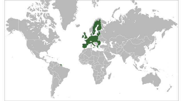
Summary
| Description |
Locator map for the in 2007 |
|---|---|
| Source |
English Wikipedia |
| Date |
2 June 2007 |
| Author |
Ssolbergj |
| Permission ( Reusing this image) |
See below
|
Licensing
 |
Permission is granted to copy, distribute and/or modify this document under the terms of the GNU Free Documentation License, Version 1.2 or any later version published by the Free Software Foundation; with no Invariant Sections, no Front-Cover Texts, and no Back-Cover Texts. Subject to disclaimers. Asturianu | Български | Català | Deutsch | English | Español | Français | Gaeilge | Italiano | Polski | Português | +/- |
File history
Click on a date/time to view the file as it appeared at that time.
| Date/Time | Dimensions | User | Comment | |
|---|---|---|---|---|
| current | 14:38, 21 May 2008 | 999×553 (573 KB) | Ssolbergj | ({{Information |Description= |Source= |Date= |Author= |Permission= |other_versions= }} ) |
| 14:36, 21 May 2008 | 999×628 (573 KB) | Ssolbergj | ({{Information |Description= |Source= |Date= |Author= |Permission= |other_versions= }} ) | |
| 14:31, 21 May 2008 | 999×634 (573 KB) | Ssolbergj | ({{Information |Description= |Source= |Date= |Author= |Permission= |other_versions= }} ) | |
| 12:55, 19 May 2008 | 250×170 (560 KB) | Ssolbergj | (Reverted to version as of 17:04, 26 February 2008) | |
| 12:54, 19 May 2008 | 1,052×695 (573 KB) | Ssolbergj | ({{Information |Description= |Source= |Date= |Author= |Permission= |other_versions= }} ) | |
| 17:04, 26 February 2008 | 250×170 (560 KB) | Ssolbergj | (I wrote an edit summary, and so should you. The Robinson projection does squeeze Europe. The Mercator projection is more appropriate for the European Union.) | |
| 17:15, 24 February 2008 | 940×477 (2.29 MB) | Barryob | (Reverted to version as of 23:57, 12 June 2007) | |
| 01:47, 18 February 2008 | 250×170 (560 KB) | Ssolbergj | ({{Information |Description= |Source= |Date= |Author= |Permission= |other_versions= }} ) | |
| 01:32, 18 February 2008 | 1,021×674 (561 KB) | Ssolbergj | ({{Information |Description= |Source= |Date= |Author= |Permission= |other_versions= }} ) | |
| 01:12, 18 February 2008 | 1,021×674 (561 KB) | Ssolbergj | (A map projection that doesn't distort the northern hemisphere so much.) | |
| 23:57, 12 June 2007 | 940×477 (2.29 MB) | Guilherme Paula | (== Summary == {{Information |Description=Locator map for the European Union in 2007 |Source=English Wikipedia |Date=2 June 2007 |Author= en:User:Ssolbergj |Permission=See below }} == Licensing == {{GFDL-with-disclaimers}} [[Categ) |
File links
The following pages on Schools Wikipedia link to this image (list may be incomplete):