Image:British Empire 1921 IndianSubcontinent.png

From Wikipedia, the free encyclopedia

Wikimedia Commons logo This is a file from the Wikimedia Commons. The description on its description page there is shown below.
Commons is a freely licensed media file repository. You can help.

Summary

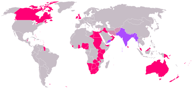
The British Empire at its zenith in 1919; countries of the Indian subcontinent under British dominion are highlighted in violet.

Image based on GFDL Image:British Empire 1921.png by w:Arthur Wellesley

Update history:

  • Following regions have been discounted: North of Aden, Lebanon, New Caledonia, Goa, Daman, Pondicherry
  • Region added: Nicaragua
  • Regions added: Russia, Mexico, United States, Brazil
  • Discounted Sri Lanka: was being administered separately from w:British Raj

Licensing

I, the copyright holder of this work, hereby publish it under the following licenses:
GNU head Permission is granted to copy, distribute and/or modify this document under the terms of the GNU Free Documentation license, Version 1.2 or any later version published by the Free Software Foundation; with no Invariant Sections, no Front-Cover Texts, and no Back-Cover Texts. A copy of the license is included in the section entitled " GNU Free Documentation license".

Aragonés | العربية | Asturianu | Беларуская (тарашкевіца) | Български | বাংলা | ইমার ঠার/বিষ্ণুপ্রিয়া মণিপুরী | Brezhoneg | Bosanski | Català | Cebuano | Česky | Dansk | Deutsch | Ελληνικά | English | Esperanto | Español | Eesti | Euskara | فارسی | Suomi | Français | Gaeilge | Galego | עברית | Hrvatski | Magyar | Bahasa Indonesia | Ido | Íslenska | Italiano | 日本語 | ქართული | ភាសាខ្មែរ | 한국어 | Kurdî / كوردی | Latina | Lëtzebuergesch | Lietuvių | Bahasa Melayu | Nnapulitano | Nederlands | ‪Norsk (nynorsk)‬ | ‪Norsk (bokmål)‬ | Occitan | Polski | Português | Română | Русский | Slovenčina | Slovenščina | Shqip | Српски / Srpski | Svenska | తెలుగు | ไทย | Tagalog | Türkçe | Українська | اردو | Tiếng Việt | Volapük | Yorùbá | ‪中文(简体)‬ | ‪中文(繁體)‬ | +/-

Some rights reserved
Creative Commons Attribution icon Creative Commons Share Alike icon
This file is licensed under the Creative Commons Attribution ShareAlike license versions 2.5, 2.0, and 1.0

العربية | Български | Català | Česky | Dansk | Deutsch | English | Español | Euskara | فارسی | Français | Galego | עברית | Italiano | 日本語 | 한국어 | Lietuvių | Nederlands | Polski | Português | Русский | Svenska | தமிழ் | తెలుగు | Türkçe | 中文 | 中文 | +/-

You may select the license of your choice.

File history

Click on a date/time to view the file as it appeared at that time.

Date/Time Dimensions User Comment
current 18:03, 11 January 2006 1,345×614 (28 KB) Miljoshi (More Changes as per w:Talk:British Raj.)
10:21, 9 January 2006 1,345×614 (28 KB) Miljoshi (Correcting wrong inclusion of Nicaragua - w:User:Big Adamsky)
11:51, 6 January 2006 1,345×614 (22 KB) Miljoshi (Discounting Sri Lanka)
10:30, 6 January 2006 1,345×614 (22 KB) Miljoshi (Updated map with corrections in Aden, Lebanon, Nicaragua, New Caledonia, Goa, Daman, Pondycherri.)
17:01, 5 January 2006 1,345×614 (23 KB) Miljoshi (British Empire in 1921 - Indian subcontinent is highlighted in purple. Image based on GFDL Image:British Empire 1921.png by w:Arthur Wellesley)
The following pages on Schools Wikipedia link to this image (list may be incomplete):
The Schools Wikipedia is sponsored by SOS Children , and consists of a hand selection from the English Wikipedia articles with only minor deletions (see www.wikipedia.org for details of authors and sources). See also our Disclaimer.