Image:Satsop Development Park 07780.JPG
From Wikipedia, the free encyclopedia
Size of this preview: 640 × 480 pixels
Full resolution (2,560 × 1,920 pixels, file size: 1.34 MB, MIME type: image/jpeg)
| |
This is a file from the Wikimedia Commons. The description on its description page there is shown below. |
Summary
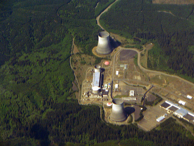
Satsop, Washington
- Description: Satsop Development Park; formerly Washington Public Power Supply System Nuclear Power Plans 3 and 5; ( Satsop, Washington)
- Viewpoint location: Flight 334 from Seattle/Tacoma, WA to Oakland, CA Alaska Airlines
- Lat/Long: 46.9605° N 123.4670° W (WGS84/NAD83)
- Maps and aerial photos
- Topographic map from TopoZone
- Aerial image from TerraServer-USA
- Surrounding area map from Google Maps
- Viewpoint elevation: ~3500 m
- View direction: West
- Date and time: 2006.05.09 10:59:22 PDT
- Camera: Panasonic Lumix DMC FZ5
- Photographer: Walter Siegmund
©2006 Walter Siegmund
Licensing
|

File history
Click on a date/time to view the file as it appeared at that time.
| Date/Time | Dimensions | User | Comment | |
|---|---|---|---|---|
| current | 20:21, 17 September 2006 | 2,560×1,920 (1.34 MB) | Wsiegmund | (Photoshop/Adjust/Levels) |
| 19:47, 17 September 2006 | 2,560×1,920 (1.42 MB) | Wsiegmund | ('''Satsop, Washington''' * '''Description:''' Satsop Development Park; formerly Washington Public Power Supply System Nuclear Power Plans 3 and 5; ( Satsop, Washington) * '''Viewpoint location:''' Flight 334 from Seattle/Tacoma, WA to Oakland, CA [[Ala) |