Image:World 820.png
From Wikipedia, the free encyclopedia
Size of this preview: 640 × 320 pixels
Full resolution (1,200 × 600 pixels, file size: 42 KB, MIME type: image/png)
| |
This is a file from the Wikimedia Commons. The description on its description page there is shown below. |
Summary
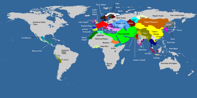
Map of the world, c. AD 820. Colored areas show the extent of influence for the major empires of the period; control over some areas may have been purely nominal. Gray areas showed areas that are mainly inhabited by Indigineous populations, or completely uninhabited.
| Maps of world history | |
| BC |
2000 · 1500 · 1000 · 500 · 400 · 323 · 300 · 200 · 100 · 50 |
|
|
|
| AD |
1 · 50 · 100 · 200 · 250 · 300 · 400 · 450 · 500 · 600 · 700 · 750 · 800 · 820 · 900 · 1000 · 1300 · 1492 · 1550 · 1660 · 1754 · 1822 · 1885 · 1898 · 1914 · 1920 · 1936 · 1938 · 1945 · 1959 · 1959 · 1974 · 1980 · 2007 |
| (this template: · view · discuss ) | |
 |
This map image should be recreated using vector graphics as an SVG file. This has several advantages; see Commons:Media for cleanup for more information. If an SVG form of this image is already available, please upload it. After uploading an SVG, replace this template with {{ vector version available|new image name.svg}}. |
|
العربية | Български | Català | Česky | Dansk | Deutsch | English | Esperanto | Español | Français | Galego | 한국어 | Italiano | Magyar | Lietuvių | Nederlands | 日本語 | Polski | Português | Română | Русский | Suomi | Svenska | Türkçe | Українська | 中文(繁體) | 中文(简体) | +/- |
|
Licensing
 |
Permission is granted to copy, distribute and/or modify this document under the terms of the GNU Free Documentation License, Version 1.2 or any later version published by the Free Software Foundation; with no Invariant Sections, no Front-Cover Texts, and no Back-Cover Texts. Subject to disclaimers. Asturianu | Български | Català | Deutsch | English | Español | Français | Gaeilge | Italiano | Polski | Português | +/- |
File history
Click on a date/time to view the file as it appeared at that time.
| Date/Time | Dimensions | User | Comment | |
|---|---|---|---|---|
| current | 17:54, 3 May 2008 | 1,200×600 (42 KB) | Huhsunqu | |
| 00:47, 20 May 2006 | 1,200×600 (41 KB) | Ikiroid | (Reverted to earlier revision) | |
| 14:40, 10 February 2006 | 800×314 (97 KB) | Dbachmann | (cropped) | |
| 08:52, 17 January 2006 | 1,200×600 (41 KB) | Jrohr | (== Summary == Map of the world, c. 820 CE. Colored areas show the extent of influence for the major empires of the period; control over some areas may have been purely nominal. Category:Historical maps by User:Briangotts ) |