Image:Geocentric vs geodetic latitude with elevation.svg
From Wikipedia, the free encyclopedia
Geocentric_vs_geodetic_latitude_with_elevation.svg (SVG file, nominally 300 × 275 pixels, file size: 93 KB)
| |
This is a file from the Wikimedia Commons. The description on its description page there is shown below. |
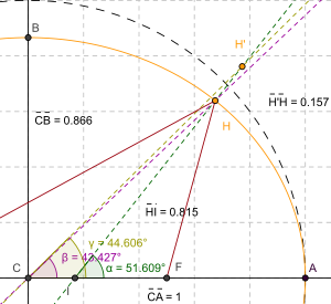
Summary
| Description |
Shows how corrections have to be made for height (altitude) when converting from geodetic to geocentric coordinates. Point H is a point on the surface of a spheroid. This point has a geodetic latitude (α) and a geocentric latitude (β). Point H' is a point sharing the same geodetic latitude as point H, but is at a higher altitude and has a different geocentric latitude (γ). |
|---|---|
| Source |
self-made |
| Date |
2008-02-16 |
| Author |
SharkD |
| Permission ( Reusing this image) |
see below |
| Other versions | Image:Geocentric vs geodetic latitude.svg, Image:Circle of latitude elevation.svg |
Licensing
 |
I, the copyright holder of this work, hereby release it into the public domain. This applies worldwide. In case this is not legally possible: Afrikaans | Alemannisch | Aragonés | العربية | Asturianu | Български | Català | Cebuano | Česky | Cymraeg | Dansk | Deutsch | Eʋegbe | Ελληνικά | English | Español | Esperanto | Euskara | Estremeñu | فارسی | Français | Galego | 한국어 | हिन्दी | Hrvatski | Ido | Bahasa Indonesia | Íslenska | Italiano | עברית | Kurdî / كوردی | Latina | Lietuvių | Latviešu | Magyar | Македонски | Bahasa Melayu | Nederlands | Norsk (bokmål) | Norsk (nynorsk) | 日本語 | Polski | Português | Ripoarisch | Română | Русский | Shqip | Slovenčina | Slovenščina | Српски / Srpski | Suomi | Svenska | ไทย | Tagalog | Türkçe | Українська | Tiếng Việt | Walon | 中文(简体) | 中文(繁體) | zh-yue-hant | +/- |
File history
Click on a date/time to view the file as it appeared at that time.
| Date/Time | Dimensions | User | Comment | |
|---|---|---|---|---|
| current | 23:36, 6 August 2008 | 300×275 (93 KB) | SharkD | (changed style of lines) |
| 23:35, 6 August 2008 | 300×275 (93 KB) | SharkD | (matched color of lines to colour of angles) | |
| 04:39, 6 August 2008 | 300×275 (95 KB) | SharkD | (image dimensions are now more convenient) | |
| 04:33, 6 August 2008 | 339×311 (95 KB) | SharkD | (changed colour of one of the angle measurements to purple) | |
| 04:31, 6 August 2008 | 339×311 (95 KB) | SharkD | (angle measurements were overlapping) | |
| 04:30, 6 August 2008 | 339×311 (95 KB) | SharkD | (Less wasted space, more readable in thumbnail sizes.) | |
| 03:00, 8 March 2008 | 830×633 (59 KB) | SharkD | (Angle markers were too hard to distinguish.) | |
| 20:15, 16 February 2008 | 830×633 (61 KB) | SharkD | (Image was too small.) | |
| 20:00, 16 February 2008 | 415×316 (61 KB) | SharkD | ({{Information |Description=Shows how corrections have to be made for height (altitude) when converting from geodetic to geocentric coordinates. |Source=self-made |Date=2008-02-16 |Author= SharkD |Permission= |other_versions= }} ) |