Image:Types of latitude difference.png
From Wikipedia, the free encyclopedia
No higher resolution available.
Types_of_latitude_difference.png (512 × 384 pixels, file size: 4 KB, MIME type: image/png)
| |
This is a file from the Wikimedia Commons. The description on its description page there is shown below. |
Contents |
Summary
| Description |
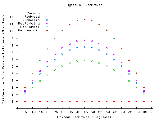
Comparison between different types of latitude (common, reduced, authalic, rectifying, conformal, geocentric) that shows the difference from the common latitude |
|---|---|
| Source |
Own work with the help of gnuplot |
| Date |
August 16, 2006 |
| Author |
User:Cburnett |
| Permission ( Reusing this image) |
GFDL |
| Other versions | Image:Types of latitudes original.png (shows actual values) |
Source
The following gnuplot code is released under the GPL:
 |
This work is free software; you can redistribute it and/or modify it under the terms of the GNU General Public License as published by the Free Software Foundation; either version 2 of the License, or any later version. This work is distributed in the hope that it will be useful, but WITHOUT ANY WARRANTY; without even the implied warranty of MERCHANTABILITY or FITNESS FOR A PARTICULAR PURPOSE. See version 2 and version 3 of the GNU General Public License for more details. العربية | Català | Česky | Deutsch | Ελληνικά | English | Español | Français | Italiano | 日本語 | Nederlands | Polski | Português | Русский | Slovenčina | 中文(简体) | 中文(繁體) | +/- |
set term png small notransparent
set output "Types of latitude difference.png"

set title "Types of Latitude"
set xlabel "Common Latitude (Degrees)"
set xtics nomirror 0,5,90
set xrange [-1:91]

set ylabel "Difference from Common Latitude (Minutes)"
set ytics nomirror 0,1,12
set yrange [-1:13]

set size 0.8,0.8

set key left top

plot \
    "data_difference.dat" using 1:2 title 'Common', \
    "data_difference.dat" using 1:3 title 'Reduced', \
    "data_difference.dat" using 1:4 title 'Authalic', \
    "data_difference.dat" using 1:5 title 'Rectifying', \
    "data_difference.dat" using 1:6 title 'Conformal', \
    "data_difference.dat" using 1:7 title 'Geocentric'
Source data
The following data was taken from and saved in data_difference.dat:
0.00    0.00    0.00    0.00    0.00    0.00    0.00
5.00    0.00    1.01    1.35    1.52    2.02    2.02
10.00   0.00    1.99    2.66    2.99    3.98    3.98
15.00   0.00    2.91    3.89    4.37    5.82    5.82
20.00   0.00    3.75    5.00    5.62    7.48    7.48
25.00   0.00    4.47    5.96    6.70    8.92    8.92
30.00   0.00    5.05    6.73    7.57    10.09   10.09
35.00   0.00    5.48    7.31    8.22    10.95   10.96
40.00   0.00    5.75    7.66    8.62    11.48   11.49
45.00   0.00    5.84    7.78    8.76    11.67   11.67
50.00   0.00    5.75    7.67    8.63    11.50   11.50
55.00   0.00    5.49    7.32    8.23    10.97   10.98
60.00   0.00    5.06    6.75    7.59    10.12   10.13
65.00   0.00    4.48    5.97    6.72    8.95    8.96
70.00   0.00    3.76    5.01    5.64    7.52    7.52
75.00   0.00    2.92    3.90    4.39    5.85    5.85
80.00   0.00    2.00    2.67    3.00    4.00    4.01
85.00   0.00    1.02    1.35    1.52    2.03    2.03
90.00   0.00    0.00    0.00    0.00    0.00    0.00
Licensing
The image itself is released under the GFDL:
|
| |
This vector image was created with gnuplot. |
File history
Click on a date/time to view the file as it appeared at that time.
| Date/Time | Dimensions | User | Comment | |
|---|---|---|---|---|
| current | 00:04, 17 August 2006 | 512×384 (4 KB) | Cburnett | (Misread, data was in minutes not degrees so y label is wrong) |
| 23:56, 16 August 2006 | 512×384 (4 KB) | Cburnett | ({{Information |Description=Comparison between different types of latitude (common, reduced, authalic, rectifying, conformal, geocentric) that shows the ''difference'' from the common latitude |Source=Own work with the help of gnuplot |Date= August 16, ) |