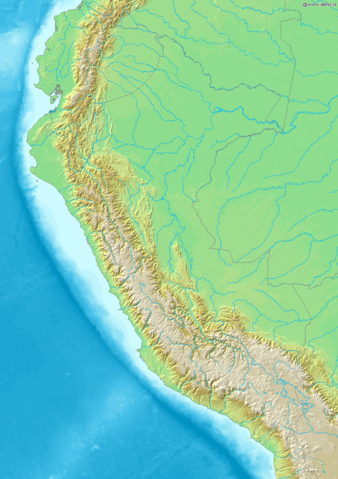
Image:Map of Peru Demis.png
From Wikipedia, the free encyclopedia
Size of this preview: 338 × 479 pixels
Full resolution (840 × 1,191 pixels, file size: 431 KB, MIME type: image/png)
| |
This is a file from the Wikimedia Commons. The description on its description page there is shown below. |
Map of Peru
Bounding box West -82.5°, South -19.5°, East -67.5°, North 1.5°. Centre at 9.00000° S 75.00000° W.
 |
This image is in the public domain because came from the site http://www.demis.nl/home/pages/Gallery/examples.htm and was released by the copyright holder. Permission is granted to copy, distribute and/or modify this map since it is based on free of copyright images from: www.demis.nl. See also approval email on de.wp and its clarification. |
 A vector version of this image (SVG) is available. For more information about vector graphics, read about Commons transition to SVG. Deutsch | English | Español | Français | Galego | עברית | Magyar | Italiano | 日本語 | 한국어 | Lietuvių | Polski | Português | Русский | Српски / Srpski | Українська | +/- |
 |
File history
Click on a date/time to view the file as it appeared at that time.
| Date/Time | Dimensions | User | Comment | |
|---|---|---|---|---|
| current | 20:26, 20 December 2006 | 840×1,191 (431 KB) | Mats Halldin | (Map of Peru Bounding box West -82.5°, South -19.5°, East -67.5°, North 1.5°. Centre at {{coor d|9.00000|S|75.00000|W|scale:12600000}}. {{demis-pd}} category:maps of Peru ) |
File links
The following pages on Schools Wikipedia link to this image (list may be incomplete):