Image:Österreich-Ungarns Ende.png
From Wikipedia, the free encyclopedia
Size of this preview: 640 × 396 pixels
Full resolution (1,568 × 970 pixels, file size: 80 KB, MIME type: image/png)
| |
This is a file from the Wikimedia Commons. The description on its description page there is shown below. |
|
|
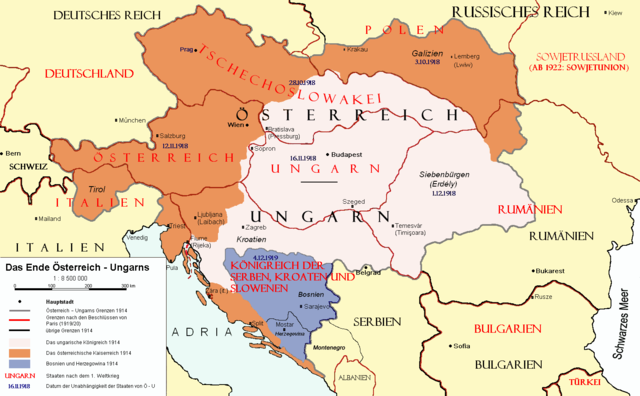
Border of Austria-Hungary in 1914 |
|
|
Borders in 1914 |
|
|
Borders in 1920 |
██ Empire of Austria in 1914
██ Kingdom of Hungary in 1914
██ Bosnia and Herzegovina in 1914
 |
Permission is granted to copy, distribute and/or modify this document under the terms of the GNU Free Documentation license, Version 1.2 or any later version published by the Free Software Foundation; with no Invariant Sections, no Front-Cover Texts, and no Back-Cover Texts. A copy of the license is included in the section entitled " GNU Free Documentation license". Aragonés | العربية | Asturianu | Беларуская (тарашкевіца) | Български | বাংলা | ইমার ঠার/বিষ্ণুপ্রিয়া মণিপুরী | Brezhoneg | Bosanski | Català | Cebuano | Česky | Dansk | Deutsch | Ελληνικά | English | Esperanto | Español | Eesti | Euskara | فارسی | Suomi | Français | Gaeilge | Galego | עברית | Hrvatski | Magyar | Bahasa Indonesia | Ido | Íslenska | Italiano | 日本語 | ქართული | ភាសាខ្មែរ | 한국어 | Kurdî / كوردی | Latina | Lëtzebuergesch | Lietuvių | Bahasa Melayu | Nnapulitano | Nederlands | Norsk (nynorsk) | Norsk (bokmål) | Occitan | Polski | Português | Română | Русский | Slovenčina | Slovenščina | Shqip | Српски / Srpski | Svenska | తెలుగు | ไทย | Tagalog | Türkçe | Українська | اردو | Tiếng Việt | Volapük | Yorùbá | 中文(简体) | 中文(繁體) | +/- |
 |
This map image should be recreated using vector graphics as an SVG file. This has several advantages; see Commons:Media for cleanup for more information. If an SVG form of this image is already available, please upload it. After uploading an SVG, replace this template with {{ vector version available|new image name.svg}}. |
|
العربية | Български | Català | Česky | Dansk | Deutsch | English | Esperanto | Español | Français | Galego | 한국어 | Italiano | Magyar | Lietuvių | Nederlands | 日本語 | Polski | Português | Română | Русский | Suomi | Svenska | Türkçe | Українська | 中文(繁體) | 中文(简体) | +/- |
|
File history
Click on a date/time to view the file as it appeared at that time.
| Date/Time | Dimensions | User | Comment | |
|---|---|---|---|---|
| current | 11:59, 16 July 2007 | 1,568×970 (80 KB) | Nihad Hamzic | (The original image seems to had been saved as JPEG, and that some previous uploader had simply directly converted it to PNG. I have greatly optimised its size by removing JPEG artifacts, reducing colour domain, etc.) |
| 20:47, 23 January 2006 | 1,568×970 (903 KB) | AlphaCentauri | (kleine Änderungen) | |
| 14:27, 23 September 2005 | 1,568×970 (903 KB) | AlphaCentauri | (Laibach and Triest) | |
| 03:29, 17 September 2005 | 1,568×970 (347 KB) | Berkut | (better file compression) | |
| 09:39, 16 September 2005 | 1,568×970 (428 KB) | Kallgan | (Das Ende Österreich-Ungarns nach dem Pariser Vorortverträgen. Selbsterstellte Karte. {{Bild-GFDL}} (Borders between Romania and Bulgaria in Dobrogea modified)(Source: Goode's World Atlas, Rand McNally & Company, 1932 & 1933, Chicago, U.S.) ) | |
| 13:39, 4 July 2005 | 1,568×970 (903 KB) | AlphaCentauri | (verbessert) | |
| 19:29, 28 April 2005 | 1,568×970 (903 KB) | AlphaCentauri | (so, nochmals verbessert) | |
| 18:45, 12 April 2005 | 1,568×970 (903 KB) | AlphaCentauri | (nochmals verbessert) | |
| 15:06, 12 April 2005 | 1,568×970 (903 KB) | AlphaCentauri | ||
| 14:47, 12 April 2005 | 1,568×970 (903 KB) | AlphaCentauri | (verbesserte Version) | |
| 20:59, 5 January 2005 | 1,568×970 (903 KB) | AlphaCentauri | (verbesserte Version) | |
| 10:14, 29 December 2004 | 1,568×970 (903 KB) | AlphaCentauri | (Das Ende Österreich-Ungarns (Karte)) |