Image:European settlements in India 1498-1739.PNG
From Wikipedia, the free encyclopedia
Size of this preview: 640 × 393 pixels
Full resolution (1,140 × 700 pixels, file size: 175 KB, MIME type: image/png)
Licensing
|
Summary
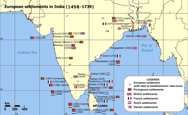
Map of India with Sri Lanka, illustrating locations of European settlements in the subcontinent between 1498 and 1739.
Map reference: at w:University of Pennsylvania, with reference varification from: (URL accessed: 23-Mar-2006)EricSRodrigues154 03:28, 21 September 2007 (UTC)
File links
The following pages on the English Wikipedia link to this file (pages on other projects are not listed):
File history
Click on a date/time to view the file as it appeared at that time.
| Date/Time | Dimensions | User | Comment | |
|---|---|---|---|---|
| current | 03:44, 21 September 2007 | 1,140×700 (175 KB) | EricSRodrigues154 ( Talk | contribs) | (== Summary == Map of India with Sri Lanka, illustrating locations of European settlements in the subcontinent between 1501 and 1739. Map reference: [http://www.history.upenn.edu/coursepages/hist086/material/schmidt26a.jpg] at [[w:University of Pennsylvan) |
| revert | 03:36, 21 September 2007 | 1,140×700 (176 KB) | EricSRodrigues154 ( Talk | contribs) | (== Summary == Map of India with Sri Lanka, illustrating locations of European settlements in the subcontinent between 1498 and 1739. Map reference: [http://www.history.upenn.edu/coursepages/hist086/material/schmidt26a.jpg] at [[w:University of Pennsylvan) |
| revert | 03:32, 21 September 2007 | 1,140×700 (176 KB) | EricSRodrigues154 ( Talk | contribs) | (== Summary == Map of India with Sri Lanka, illustrating locations of European settlements in the subcontinent between 1501 and 1739. Map reference: [http://www.history.upenn.edu/coursepages/hist086/material/schmidt26a.jpg] at [[w:University of Pennsylvan) |
| revert | 03:29, 21 September 2007 | 1,140×700 (176 KB) | EricSRodrigues154 ( Talk | contribs) | (== Summary == Map of India with Sri Lanka, illustrating locations of European settlements in the subcontinent between 1498 and 1739. Map reference: [http://www.history.upenn.edu/coursepages/hist086/material/schmidt26a.jpg] at [[w:University of Pennsylvan) |
| revert | 03:28, 21 September 2007 | 1,140×700 (176 KB) | EricSRodrigues154 ( Talk | contribs) | (== Summary == Map of India with Sri Lanka, illustrating locations of European settlements in the subcontinent between 1498 and 1739. Map reference: [http://www.history.upenn.edu/coursepages/hist086/material/schmidt26a.jpg] at [[w:University of Pennsylvan) |
See the setup instructions for more information.
File links
The following pages on Schools Wikipedia link to this image (list may be incomplete):
Categories: Creative Commons Attribution-ShareAlike 2.5 images | Self-published work | Maps of India