Image:Salvation army world map.PNG
From Wikipedia, the free encyclopedia
Size of this preview: 640 × 296 pixels
Full resolution (1,357 × 628 pixels, file size: 64 KB, MIME type: image/png)
| |
This is a file from the Wikimedia Commons. The description on its description page there is shown below. |
Summary
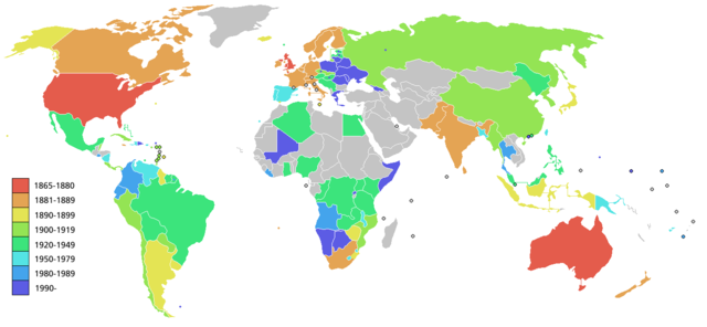
Map showing the Worldwide expansion of the Salvation Army as listed on w:Salvation Army (some areas shown are countries, other are regions). Since the map refers to locations over a 140 year period, some countries may not correspond exactly to the area of the original historic country where the Salvation army was originally founded in.
Note that countries where Salvation army recommenced are shown with a dot in the appropriate colour, while the whole country is shown in the colour of the original founding date.
Licensing
 |
Permission is granted to copy, distribute and/or modify this document under the terms of the GNU Free Documentation license, Version 1.2 or any later version published by the Free Software Foundation; with no Invariant Sections, no Front-Cover Texts, and no Back-Cover Texts. A copy of the license is included in the section entitled " GNU Free Documentation license". Aragonés | العربية | Asturianu | Беларуская (тарашкевіца) | Български | বাংলা | ইমার ঠার/বিষ্ণুপ্রিয়া মণিপুরী | Brezhoneg | Bosanski | Català | Cebuano | Česky | Dansk | Deutsch | Ελληνικά | English | Esperanto | Español | Eesti | Euskara | فارسی | Suomi | Français | Gaeilge | Galego | עברית | Hrvatski | Magyar | Bahasa Indonesia | Ido | Íslenska | Italiano | 日本語 | ქართული | ភាសាខ្មែរ | 한국어 | Kurdî / كوردی | Latina | Lëtzebuergesch | Lietuvių | Bahasa Melayu | Nnapulitano | Nederlands | Norsk (nynorsk) | Norsk (bokmål) | Occitan | Polski | Português | Română | Русский | Slovenčina | Slovenščina | Shqip | Српски / Srpski | Svenska | తెలుగు | ไทย | Tagalog | Türkçe | Українська | اردو | Tiếng Việt | Volapük | Yorùbá | 中文(简体) | 中文(繁體) | +/- |
File history
Click on a date/time to view the file as it appeared at that time.
| Date/Time | Dimensions | User | Comment | |
|---|---|---|---|---|
| current | 11:28, 20 May 2008 | 1,357×628 (64 KB) | Ictys | (And Greec) |
| 11:24, 20 May 2008 | 1,357×628 (64 KB) | Ictys | (New version with Namibia and Mali) | |
| 14:28, 26 February 2006 | 1,357×628 (37 KB) | Roke | (Map showing the Worldwide expansion of the Salvation Army. Since the map refers to locations over a 140 year period, some countries may not correspond exactly to the area of the original historic country where the Salvation army was originally founded in.) |