Image:Korea north map.png
From Wikipedia, the free encyclopedia
Size of this preview: 456 × 480 pixels
Full resolution (573 × 603 pixels, file size: 24 KB, MIME type: image/png)
| |
This is a file from the Wikimedia Commons. The description on its description page there is shown below. |
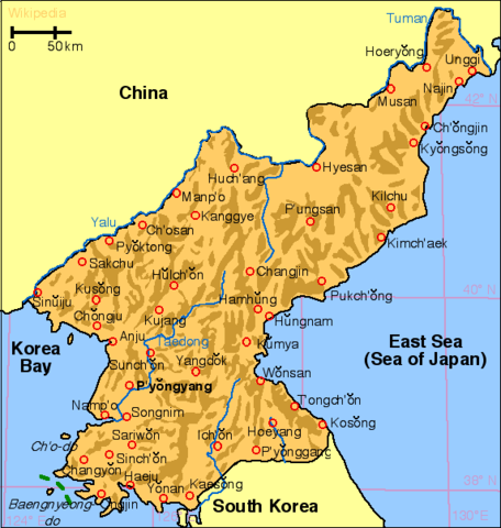
- This is a map of North Korea showing major settlements.
- The map was drawn by en:user:Kokiri
- License: Gnu-FDL
- Source: en-Wikipedia, en:Image:Korea_north_map.png
- File history:
- (del) (cur) 21:23, 24 Apr 2005 . . Berkut (24666 bytes)
- (del) (rev) 10:52, 20 Aug 2004 . . Kokiri (40173 bytes) (this version got scale bars)
- (del) (rev) 10:38, 20 Aug 2004 . . Kokiri (39874 bytes) (north korea map, drawn myself)
- Version history:
- cur) (last) 22:03, 27 Aug 2004 Kokiri (licensing)
- (cur) (last) 01:23, 25 Aug 2004 64.56.247.211
- (cur) (last) 14:12, 20 Aug 2004 Kokiri m (rm comment on relief since it's no longer necessary)
- (cur) (last) 10:43, 20 Aug 2004 Kokiri (updated image description; added warning about relief shadings)
- (cur) (last) 10:38, 20 Aug 2004 Kokiri (north korea map, drawn myself)
 |
Permission is granted to copy, distribute and/or modify this document under the terms of the GNU Free Documentation license, Version 1.2 or any later version published by the Free Software Foundation; with no Invariant Sections, no Front-Cover Texts, and no Back-Cover Texts. A copy of the license is included in the section entitled " GNU Free Documentation license". Aragonés | العربية | Asturianu | Беларуская (тарашкевіца) | Български | বাংলা | ইমার ঠার/বিষ্ণুপ্রিয়া মণিপুরী | Brezhoneg | Bosanski | Català | Cebuano | Česky | Dansk | Deutsch | Ελληνικά | English | Esperanto | Español | Eesti | Euskara | فارسی | Suomi | Français | Gaeilge | Galego | עברית | Hrvatski | Magyar | Bahasa Indonesia | Ido | Íslenska | Italiano | 日本語 | ქართული | ភាសាខ្មែរ | 한국어 | Kurdî / كوردی | Latina | Lëtzebuergesch | Lietuvių | Bahasa Melayu | Nnapulitano | Nederlands | Norsk (nynorsk) | Norsk (bokmål) | Occitan | Polski | Português | Română | Русский | Slovenčina | Slovenščina | Shqip | Српски / Srpski | Svenska | తెలుగు | ไทย | Tagalog | Türkçe | Українська | اردو | Tiếng Việt | Volapük | Yorùbá | 中文(简体) | 中文(繁體) | +/- |
File history
Click on a date/time to view the file as it appeared at that time.
| Date/Time | Dimensions | User | Comment | |
|---|---|---|---|---|
| current | 16:03, 28 January 2007 | 573×603 (24 KB) | Tene | (Optimised (no filter, 512 block split)) |
| 11:38, 16 May 2005 | 573×603 (24 KB) | Svencb | (* This is a map of North Korea showing major settlements. * The map was drawn by * License: Gnu-FDL * Source: en-Wikipedia, en:Image:Korea_north_map.png * Version history: **(del) (cur) 21:23, 24 Apr 2005 . . Berkut (24666 bytes) **(del) (rev) 10:52) |