Image:Kashmir map.jpg
From Wikipedia, the free encyclopedia
Size of this preview: 408 × 479 pixels
Full resolution (1,029 × 1,209 pixels, file size: 310 KB, MIME type: image/jpeg)
| |
This is a file from the Wikimedia Commons. The description on its description page there is shown below. |
SVG
| |
This map image was uploaded in a raster image format such as PNG, GIF, or JPEG. However, it contains information that could be stored more efficiently and/or accurately in the SVG format, as a vector graphic. If possible, please upload an SVG version of this image. After doing so, please replace all instances of the previous version throughout Wikipedia (noted under the “File links” header), tag the old version with {{ Vector version available|NewImage.svg}}, and remove this tag. For more information, see Wikipedia:Preparing images for upload. For assistance with converting to SVG, please see the Graphics Lab. |
 |
Summary
| Description |
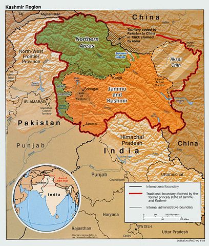
Original text from CIA World Factbook: "The Disputed Territory : Shown in green is Kashmiri region under Pakistani control. The dark-brown region represents Indian-controlled Jammu and Kashmir while the Aksai Chin is under Chinese occupation." Library of Congress, Geography and Map Division, Washington, D.C. 20540-4650 USA. Info from its archive page for this map: Kashmir region. United States. Central Intelligence Agency. CREATED/PUBLISHED [Washington : Central Intelligence Agency, 2003] NOTES "763537AI (R00744) 5-03." Relief shown by shading. Shows boundaries and disputed areas. Includes location map. Scale [ca. 1:510,000]. SUBJECTS
MEDIUM 1 map : col. ; 20 x 17 cm. CALL NUMBER G7653.J3 2003 .U51 REPOSITORY Library of Congress Geography and Map Division Washington, D.C. 20540-4650 USA DIGITAL ID g7653j ct001059 http://hdl.loc.gov/loc.gmd/g7653j.ct001059 |
|||
|---|---|---|---|---|
| Source |
Map is archived here: http://hdl.loc.gov/loc.gmd/g7653j.ct001059 and http://www.lib.utexas.edu/maps/middle_east_and_asia/kashmir_disputed_2003.jpg |
|||
| Date |
2003 |
|||
| Author |
Central Intelligence Agency |
|||
| Permission ( Reusing this image) |
|


File history
Click on a date/time to view the file as it appeared at that time.
| Date/Time | Dimensions | User | Comment | |
|---|---|---|---|---|
| current | 19:55, 10 September 2007 | 1,029×1,209 (310 KB) | Timeshifter | (Larger version of the same CIA map. {{PD-USGov-CIA-WF}} ) |
| 08:08, 13 June 2005 | 470×565 (72 KB) | Emuzesto | (From en:. Original text: The Disputed Territory : Shown in green is Kashmiri region under Pakistani control. The dark-brown region represents Indian-controlled Jammu and Kashmir while the Aksai Chin is under Chinese occupati) |
File links
Metadata
This file contains additional information, probably added from the digital camera or scanner used to create or digitize it. If the file has been modified from its original state, some details may not fully reflect the modified file.
| Orientation | Normal |
|---|---|
| Horizontal resolution | 150 dpi |
| Vertical resolution | 150 dpi |
| Software used | Adobe Photoshop 7.0 |
| File change date and time | 17:26, 4 September 2003 |
| Colour space | 65535 |