Image:India-states-numbered.svg

From Wikipedia, the free encyclopedia

India-states-numbered.svg‎ (SVG file, nominally 1,594 × 1,868 pixels, file size: 304 KB)

Wikimedia Commons logo This is a file from the Wikimedia Commons. The description on its description page there is shown below.
Commons is a freely licensed media file repository. You can help.
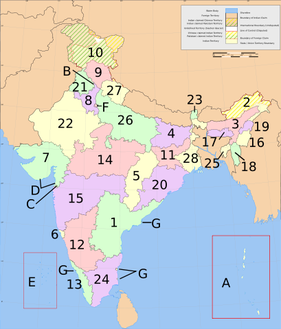
Administrative divisions of India, including 28 states and 7 union territories.

States:

  1. Goa
  2. Kerala
  1. Sikkim

Union Territories:

  1. National Capital Territory of Delhi

Summary

States of India, numbered. Based on Planemad's w:Image:India map en.svg

Licensing

I, the copyright holder of this work, hereby publish it under the following licenses:
GNU head Permission is granted to copy, distribute and/or modify this document under the terms of the GNU Free Documentation license, Version 1.2 or any later version published by the Free Software Foundation; with no Invariant Sections, no Front-Cover Texts, and no Back-Cover Texts. A copy of the license is included in the section entitled " GNU Free Documentation license".

Aragonés | العربية | Asturianu | Беларуская (тарашкевіца) | Български | বাংলা | ইমার ঠার/বিষ্ণুপ্রিয়া মণিপুরী | Brezhoneg | Bosanski | Català | Cebuano | Česky | Dansk | Deutsch | Ελληνικά | English | Esperanto | Español | Eesti | Euskara | فارسی | Suomi | Français | Gaeilge | Galego | עברית | Hrvatski | Magyar | Bahasa Indonesia | Ido | Íslenska | Italiano | 日本語 | ქართული | ភាសាខ្មែរ | 한국어 | Kurdî / كوردی | Latina | Lëtzebuergesch | Lietuvių | Bahasa Melayu | Nnapulitano | Nederlands | ‪Norsk (nynorsk)‬ | ‪Norsk (bokmål)‬ | Occitan | Polski | Português | Română | Русский | Slovenčina | Slovenščina | Shqip | Српски / Srpski | Svenska | తెలుగు | ไทย | Tagalog | Türkçe | Українська | اردو | Tiếng Việt | Volapük | Yorùbá | ‪中文(简体)‬ | ‪中文(繁體)‬ | +/-

Creative Commons License
Creative Commons Attribution icon
This file is licensed under Creative Commons Attribution 2.5 License
In short: you are free to distribute and modify the file as long as you attribute its author(s) or licensor(s).

You may select the license of your choice.

File history

Click on a date/time to view the file as it appeared at that time.

Date/Time Dimensions User Comment
current 07:51, 5 March 2007 1,594×1,868 (304 KB) Nichalp (Swapping Pondicherry NCT)
05:59, 4 March 2007 1,594×1,868 (304 KB) Nichalp (Correction in the numbering scheme according to MoS)
15:58, 15 February 2007 1,594×1,868 (304 KB) Nichalp (Reverted to earlier revision)
00:39, 12 February 2007 1,594×1,868 (304 KB) Abecedare (Reverted to earlier revision)
06:07, 25 November 2006 1,594×1,868 (304 KB) Nichalp (Reverted to earlier revision)
23:14, 17 September 2006 1,594×1,868 (304 KB) Bastique
15:22, 17 June 2006 1,594×1,868 (304 KB) Nichalp (States of India, numbered. category:Maps of India)
The following pages on Schools Wikipedia link to this image (list may be incomplete):
This Wikipedia Selection was sponsored by a UK Children's Charity, SOS Children UK , and consists of a hand selection from the English Wikipedia articles with only minor deletions (see www.wikipedia.org for details of authors and sources). See also our Disclaimer.