Image:Ghana Map.jpg
From Wikipedia, the free encyclopedia
Size of this preview: 391 × 479 pixels
Full resolution (1,060 × 1,298 pixels, file size: 309 KB, MIME type: image/jpeg)
| |
This is a file from the Wikimedia Commons. The description on its description page there is shown below. |
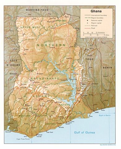
Shaded relief map of Ghana.
Image source: , from the Perry-Castañeda Library Map Collection.
 |
This image is a work of a Central Intelligence Agency employee, taken or made during the course of the person's official duties. As a Work of the United States Government, all images created or made by the CIA are in the public domain, with the exception of classified information. |  |
File history
Click on a date/time to view the file as it appeared at that time.
| Date/Time | Dimensions | User | Comment | |
|---|---|---|---|---|
| current | 18:46, 3 August 2006 | 1,060×1,298 (309 KB) | DO11.10 | (Shaded relief map of Ghana. Image source: [http://www.lib.utexas.edu/maps/africa/ghana_rel95.jpg], from the [http://www.lib.utexas.edu/maps/ghana.html Perry-Castañeda Library Map Collection]. {{PD-USGov-CIA}} Category:Maps of Ghana) |
| 10:50, 21 February 2006 | 1,341×1,653 (570 KB) | Lupo | (Shaded relief map of Ghana. Image source: [http://www.lib.utexas.edu/maps/africa/ghana_rel95.jpg], from the [http://www.lib.utexas.edu/maps/ghana.html Perry-Castañeda Library Map Collection]. {{PD-USGov-CIA}} Category:Maps of Ghana) |
File links
The following pages on Schools Wikipedia link to this image (list may be incomplete):
Categories: Maps of Ghana