Image:Venezuela regiones administrativas.png
From Wikipedia, the free encyclopedia
Size of this preview: 623 × 480 pixels
Full resolution (2,160 × 1,664 pixels, file size: 382 KB, MIME type: image/png)
| |
This is a file from the Wikimedia Commons. The description on its description page there is shown below. |
 A vector version of this image (SVG) is available. For more information about vector graphics, read about Commons transition to SVG. Deutsch | English | Español | Français | Galego | עברית | Magyar | Italiano | 日本語 | 한국어 | Lietuvių | Polski | Português | Русский | Српски / Srpski | Українська | +/- |
 |
Summary
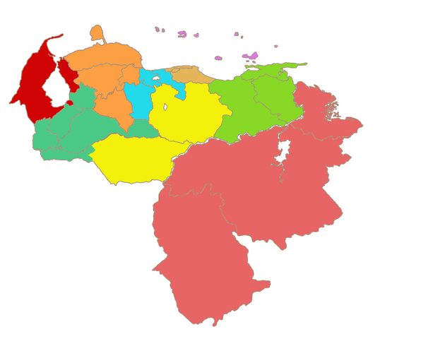
Map of Venezuela's states, coloured according to the administrative regions. Mostly the same as Image:Venezuela-portuguesa.jpg, which is GFDL. User:Jdiazch is the creator, I ( User:QuartierLatin1968) a secondary author. QuartierLatin1968 04:54, 15 March 2006 (UTC)
Legend: Zulian (red), Guayana (pink), Capital (tan), Central (blue), Central-Western (orange), Insular (purple), Andean (green), North-Eastern (light green), Llanos (yellow).
| Administrative Region | Population¹ | Area² | States |
|---|---|---|---|
| Andean Region | 3,387,449 | 65,000 km² | Barinas, Mérida, Táchira, Trujillo; Páez Municipality of Apure |
| Capital Region | 5,403,441 | 9,879 km² | Miranda, Vargas, Capital District (Caracas) |
| Central Region | 4,026,931 | 26,464 km² | Aragua, Carabobo, Cojedes |
| Central-Western Region | 3,976,319 | 66,900 km² | Falcón, Lara, Portuguesa, Yaracuy |
| Guayana Region | 1,776,545 | 458,344 km² | Bolívar, Amazonas, Delta Amacuro |
| Insular Region | 428,582 | 28,930 km² | Nueva Esparta, Federal Dependencies |
| Llanos Region | 1,181,650 | 141,486 km² | Apure (excluding Páez Municipality), Guárico |
| North-Eastern Region | 3,165,217 | 84,030 km² | Anzoátegui, Monagas, Sucre |
| Zulian Region | 3,520,376 | 63,100 km² | Zulia |
Licensing
|

File history
Click on a date/time to view the file as it appeared at that time.
| Date/Time | Dimensions | User | Comment | |
|---|---|---|---|---|
| current | 05:47, 15 March 2006 | 2,160×1,664 (382 KB) | QuartierLatin1968 | (modified so as to include Páez Municipality in the Andean region) |
| 04:54, 15 March 2006 | 2,160×1,664 (382 KB) | QuartierLatin1968 | (Map of Venezuela's states, coloured according to the administrative regions. Mostly the same as Image:Venezuela-portuguesa.jpg, which is GFDL. ~~~~ Category:Maps of Venezuela) |