Image:WestBankGovernatesNonLabeled.png
From Wikipedia, the free encyclopedia
Size of this preview: 237 × 478 pixels
Full resolution (648 × 1,308 pixels, file size: 101 KB, MIME type: image/png)
|
||
|
JENIN
Jenin
TULKARM
Tulkarm
Tubas
TUBAS
NABLUS
Nablus
Shomron
Qalqiliya
QALQILYA
Salfit
ARIEL
RAMALLAH
Ramallah and al-Bireh
Matte Binyamin
MODI'IN ILLIT
JERICHO
Biq'at HaYarden
Jericho
MA'ALE ADUMMIM
JERUSALEM
Jerusalem
BETAR ILLIT
Gush Etzion
Bethlehem
Megilot
HEBRON
Hebron
Har Hebron
YATTA
|
||

Summary
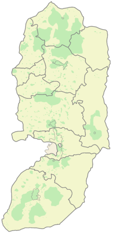
(To the right, a labeled version of this map)
Modification of existing WikiCommons map: http://upload.wikimedia.org/wikipedia/commons/f/f5/Palestine_election_map.PNG
Palestine divided into electoral districts (as of 2006), marked with thick black borders. (thinner borders show boundaries of cities, with city names marked in blue). Green shows areas of formal Palestinian authority. Map made using information from other maps such as this. There is a map of the West Bank and Gaza governates from 1995 here
Licensing
|
| |
This map image was uploaded in a raster image format such as PNG, GIF, or JPEG. However, it contains information that could be stored more efficiently and/or accurately in the SVG format, as a vector graphic. If possible, please upload an SVG version of this image. After doing so, please replace all instances of the previous version throughout Wikipedia (noted under the “File links” header), tag the old version with {{ Vector version available|NewImage.svg}}, and remove this tag. For more information, see Wikipedia:Preparing images for upload. For assistance with converting to SVG, please see the Graphics Lab. |
 |
 |
This is a candidate to be copied to the Wikimedia Commons. Appropriately licensed media are more accessible to other Wikimedia projects if placed on Commons. Any user may perform this move - please see Moving images to the Commons for more information. Please remove this tag after this image has been copied to Commons. Copy to Commons via CommonsHelper |
File history
Click on a date/time to view the file as it appeared at that time.
| Date/Time | Dimensions | User | Comment | |
|---|---|---|---|---|
| current | 15:44, 30 May 2007 | 648×1,308 (101 KB) | Abnn ( Talk | contribs) | (Modification of existing WikiCommons map: http://upload.wikimedia.org/wikipedia/commons/f/f5/Palestine_election_map.PNG ) |
See the setup instructions for more information.
File links
The following pages on Schools Wikipedia link to this image (list may be incomplete):
Categories: GFDL images | Self-published work | Maps of the West Bank | Map images that should be in SVG format | Copy to Wikimedia Commons