Image:Kashmir region-map 2004.jpg
From Wikipedia, the free encyclopedia
Size of this preview: 477 × 479 pixels
Full resolution (1,616 × 1,623 pixels, file size: 789 KB, MIME type: image/jpeg)
Summary
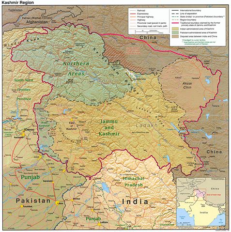
This is a public domain image downloaded from the [ http://www.lib.utexas.edu/maps/kashmir.html Perry-Castañeda Library Map Collection] at the University of Texas, Austin, by Fowler&fowler «Talk» 20:07, 29 March 2007 (UTC)
Licensing
 |
This work is in the public domain in the United States because it is a work of the United States Federal Government under the terms of Title 17, Chapter 1, Section 105 of the US Code. See Copyright. Note: This only applies to works of the Federal Government and not to the work of any individual U.S. state, territory, commonwealth, county, municipality, or any other subdivision. This template also does not apply to postage stamps published by the United States Postal Service. (See 206.02(b) of Compendium II: Copyright Office Practices). |
 |
and Albert Shenois
File history
Click on a date/time to view the file as it appeared at that time.
| Date/Time | Dimensions | User | Comment | |
|---|---|---|---|---|
| current | 20:07, 29 March 2007 | 1,616×1,623 (789 KB) | Fowler&fowler ( Talk | contribs) | (This is a [http://www.lib.utexas.edu/maps/faq.html#3.html public domain] image downloaded from the [http://www.lib.utexas.edu/maps/kashmir.html Perry-Casteneda Map Collection] at the University of Texas, Austin, by ~~~~ ) |
See the setup instructions for more information.
File links
The following file is a duplicate of this file:
The following pages on Schools Wikipedia link to this image (list may be incomplete):
Metadata
This file contains additional information, probably added from the digital camera or scanner used to create or digitize it. If the file has been modified from its original state, some details may not fully reflect the modified file.
| Orientation | Normal |
|---|---|
| Horizontal resolution | 150 dpi |
| Vertical resolution | 150 dpi |
| Software used | Adobe Photoshop 7.0 |
| File change date and time | 10:43, 10 March 2004 |
| Colour space | 65535 |
Categories: United States government images