Image:Driving standards historic.png
From Wikipedia, the free encyclopedia
Size of this preview: 640 × 296 pixels
Full resolution (1,357 × 628 pixels, file size: 19 KB, MIME type: image/png)
| |
This is a file from the Wikimedia Commons. The description on its description page there is shown below. |
Summary
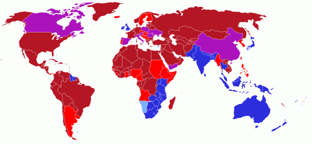
User created world map showing the driving directions for all countries and any changes that have occurred in the past starting with Finland's change in 1858
Red - driving on right; also known as Right Hand Traffic (RHT)
- Light Red - driving on right; but in the past, this modern country drove on the left.
Blue - driving on left; also known as Left Hand Traffic (LHT)
- Light Blue - driving on left; but in the past, this modern country drove on the right.
Purple - driving on right; but in the past, this modern country had different rules of the road depending on one's location.
Licensing
|
History on English Wikipedia
- (Delete all revisions of this file) (cur) 12:54, 16 June 2006 . . UKPhoenix79 (Talk | contribs | block) . . 1357×628 (19,631 bytes) (retry)
- (del) (rev) 04:59, 16 June 2006 . . UKPhoenix79 (Talk | contribs | block) . . 1357×628 (19,631 bytes) (Looking at a map of the Austro-Hungarian Empire it becae clear that more modern nations had parts that drove on the left)
- (del) (rev) 09:57, 26 May 2006 . . UKPhoenix79 (Talk | contribs | block) . . 1357×628 (19,565 bytes)
- (del) (rev) 08:11, 15 May 2006 . . UKPhoenix79 (Talk | contribs | block) . . 1357×628 (19,547 bytes) (Fixed error)
- (del) (rev) 07:36, 15 May 2006 . . UKPhoenix79 (Talk | contribs | block) . . 1357×628 (19,531 bytes)
- (del) (rev) 17:22, 14 May 2006 . . NFH (Talk | contribs | block) . . 1357×628 (19,312 bytes) (Reverted to earlier revision)
- (del) (rev) 17:21, 14 May 2006 . . NFH (Talk | contribs | block) . . 1357×628 (19,056 bytes) (Reverted to earlier revision)
- (del) (rev) 17:21, 14 May 2006 . . NFH (Talk | contribs | block) . . 1357×628 (19,056 bytes) (Reverted to earlier revision)
- (del) (rev) 23:42, 13 May 2006 . . UKPhoenix79 (Talk | contribs | block) . . 1357×628 (19,312 bytes)
- (del) (rev) 23:39, 13 May 2006 . . UKPhoenix79 (Talk | contribs | block) . . 1357×628 (19,271 bytes)
- (del) (rev) 14:00, 13 May 2006 . . UKPhoenix79 (Talk | contribs | block) . . 1357×628 (19,056 bytes) (User created world map showing historic driving directions for all countries before Finland's change in 1858 Red means driving on right.
Blue means driving on left.
)
File history
Click on a date/time to view the file as it appeared at that time.
| Date/Time | Dimensions | User | Comment | |
|---|---|---|---|---|
| current | 14:52, 27 July 2006 | 1,357×628 (19 KB) | Conscious | (newest version from en:) |
| 11:17, 26 May 2006 | 1,357×628 (19 KB) | UKPhoenix79 | (Updated version) | |
| 10:16, 13 May 2006 | 1,357×628 (19 KB) | UKPhoenix79 | (User created world map showing historic driving directions for all countries before Finland's change in 1858 <font color="#B41624">Red means driving on right.</font><br /> <font colour="#2C2EDC">Blue means driving on left.</font><br />) |
File links
The following pages on Schools Wikipedia link to this image (list may be incomplete):
Categories: World maps