Image:Countries driving on the left or right.svg
From Wikipedia, the free encyclopedia
Countries_driving_on_the_left_or_right.svg (SVG file, nominally 940 × 477 pixels, file size: 1.64 MB)
| |
This is a file from the Wikimedia Commons. The description on its description page there is shown below. |
| Description |
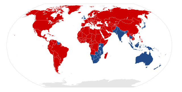
A map indicating which countries drive on the right side of the road, and which drive on the left side. |
|||
|---|---|---|---|---|
| Source | Created by bdesham in Inkscape from BlankMap-World6.svg, using information from Sens de circulation.png.
|
|||
| Date |
2007-08-30 |
|||
| Author |
Benjamin D. Esham ( bdesham) |
|||
| Permission ( Reusing this image) |
As a courtesy (but not a requirement), please e-mail me or leave a note on my talk page if you use this image outside of Wikipedia. Thanks!
|

File history
Click on a date/time to view the file as it appeared at that time.
| Date/Time | Dimensions | User | Comment | |
|---|---|---|---|---|
| current | 19:35, 22 January 2008 | 940×477 (1.64 MB) | Glentamara | (Correcting the colour of Malta and Cyprus.) |
| 15:13, 30 August 2007 | 940×477 (1.64 MB) | Bdesham | ({{User:Bdesham/Information | Description = A map indicating which countries drive on the <span style="color: #cc0000; font-weight: bold">right side</span> of the road, and which drive on the <span style="colour: #204a87; font-weight: bold">left side</span>) |