Image:Hurricane katrina damage gulfport mississippi.jpg
From Wikipedia, the free encyclopedia
Size of this preview: 640 × 426 pixels
Full resolution (3,008 × 2,000 pixels, file size: 2.64 MB, MIME type: image/jpeg)
| |
This is a file from the Wikimedia Commons. The description on its description page there is shown below. |
 |
This image is a work of a Federal Emergency Management Agency employee, taken or made during the course of an employee's official duties. As works of the U.S. federal government, all FEMA images are in the public domain. |
|
http://www.photolibrary.fema.gov/photodata/original/14801.jpg
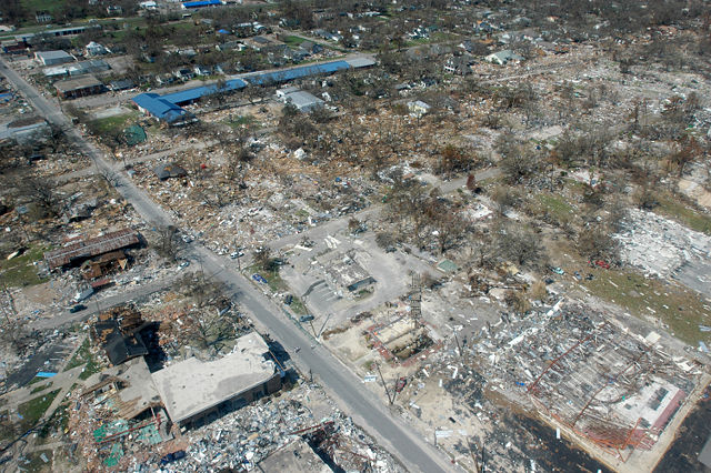
Gulfport, Miss., September 6, 2005 -- Destroyed houses in Gulfport, Miss. Hurricane Katrina caused extensive damage all along the Mississippi gulf coast. New Orleans is being evacuated as a result of flooding from hurricane Katrina and is still 60% under water. FEMA/Mark Wolfe
Hurricane Katrina damage in Long Beach, Mississippi, which is west of Gulfport and east of Pass Christian. Picture taken looking north on Jeff Davis Avenue. Long blue building to the right is Harper McCaughan Elementary School, which appears to be shifted off of its foundation. To the north of that is Long Beach Public Library, with Long Beach City Hall to the north of the library. Although these building appear to be standing, upon closer inspection, they were heavily damaged.
The east-west streets showing are (going north) 5th St, 4th St, and 3rd St (school and library intersection), 2nd St, then a little of the railroad tracks. There used to be as many houses on 4th and 5th streets as on 3rd St, and all used to have a heavy cover of trees. The picture shows a small portion of these streets, but the damaged area extends for several miles to the east and to the west. To the south of the picture (but not showing) is the beach and Highway 90.
The debris piles don't show very much in this photo, but they were at least 10 - 15 ft high in some places along 4th St. You can see it better if you notice the debris line in relation to some of the houses, which is to the roof tops on some houses.
The section of Long Beach north of the railroad tracks is making a very speedy recovery, thanks to the diligence of City workers and all of the many volunteers in the area. The outpouring of support from all over the country has been incredible and greatly appreciated.
The section of Long Beach south of the tracks is a different story, although debris removal is coming along and a very few people have moved back into their homes. All (but one) of the people on Highway 90 lost their homes completely (gone with no trace), almost all on 5th and 4th streets have lost their homes completely, and most of the homes on 2nd and 3rd streets are heavily damaged, either by wind or by water. Most did not have flood insurance, except on Highway 90.
Some of us are having to get structural engineers to tell us whether or not it is feasible to repair our home or better to tear it down and start over. People have also hired structural engineers to try to prove that the wind took their home before the tidal surge brought all of the damaging water. If they can prove the wind took it, then their homeowner's insurance should pay. Otherwise ... FEMA is supposed to help with either low interest loans or grants. Most of us have not gone that far yet. Everything is still up-in-the-air (Oct 15, 2005), even after all of this time. (Volunteer structural engineers would be a blessing!)
... from a long-time Long Beach resident
File history
Click on a date/time to view the file as it appeared at that time.
| Date/Time | Dimensions | User | Comment | |
|---|---|---|---|---|
| current | 03:42, 7 September 2005 | 3,008×2,000 (2.64 MB) | Tom | ({{PD-USGov}} http://www.photolibrary.fema.gov/photodata/original/14801.jpg Gulfport, Miss., September 6, 2005 -- Destroyed houses in Gulfport, Miss. Hurricane Katrina caused extensive damage all along the Mississippi gulf coast. New Orleans is being eva) |
File links
Metadata
This file contains additional information, probably added from the digital camera or scanner used to create or digitize it. If the file has been modified from its original state, some details may not fully reflect the modified file.
| Camera manufacturer | NIKON CORPORATION |
|---|---|
| Camera model | NIKON D70 |
| Exposure time | 1/400 sec (0.0025) |
| F-number | f/10 |
| Date and time of data generation | 16:05, 6 September 2005 |
| Lens focal length | 17 mm |
| Image title | Gulfport, Miss., September 6, 2005 -- Destroyed houses in Gulfport, Miss. Hurricane Katrina caused extensive damage all along the Mississippi gulf coast. FEMA/Mark Wolfe |
| Orientation | Normal |
| Horizontal resolution | 300 dpi |
| Vertical resolution | 300 dpi |
| Software used | Adobe Photoshop CS Windows |
| File change date and time | 17:55, 6 September 2005 |
| Author | Mark Wolfe |
| Y and C positioning | 2 |
| Exposure Program | Normal program |
| Exif version | 2.21 |
| Date and time of digitizing | 16:05, 6 September 2005 |
| Image compression mode | 4 |
| Exposure bias | 0 |
| Maximum land aperture | 3 |
| Metering mode | Pattern |
| Light source | Unknown |
| Flash | 0 |
| DateTime subseconds | 90 |
| DateTimeOriginal subseconds | 90 |
| DateTimeDigitized subseconds | 90 |
| Colour space | sRGB |
| Sensing method | One-chip colour area sensor |
| Custom image processing | Normal process |
| Exposure mode | Auto exposure |
| White balance | Auto white balance |
| Digital zoom ratio | 1 |
| Focal length in 35 mm film | 25 |
| Scene capture type | Standard |
| Contrast | Normal |
| Saturation | Normal |
| Sharpness | Normal |
| Subject distance range | Unknown |