Image:Kingdom of Mercia.png
From Wikipedia, the free encyclopedia
Size of this preview: 384 × 480 pixels
Full resolution (404 × 505 pixels, file size: 123 KB, MIME type: image/png)
| |
This is a file from the Wikimedia Commons. The description on its description page there is shown below. |
ファイルの概要
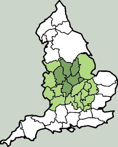
a Map of Kingdom of Mercia, England. from en:wp, .
Licensing
 |
Permission is granted to copy, distribute and/or modify this document under the terms of the GNU Free Documentation License, Version 1.2 or any later version published by the Free Software Foundation; with no Invariant Sections, no Front-Cover Texts, and no Back-Cover Texts. Subject to disclaimers. Asturianu | Български | Català | Deutsch | English | Español | Français | Gaeilge | Italiano | Polski | Português | +/- |
| Description |
I created this image. The en:Kingdom of Mercia at its greatest extent (7th to 9th centuries) is shown in green, with the original core area (6th century) given a darker tint. TharkunColl 16:23, 6 June 2006 (UTC) |
|---|---|
| Source |
Originally from en.wikipedia; description page is/was here. |
| Date |
2006-06-06 (original upload date) |
| Author |
Original uploader was TharkunColl at en.wikipedia |
| Permission ( Reusing this image) |
Licensed under the GFDL by the author; Released under the GNU Free Documentation License.
|
License information
|
NOTE: "subject to disclaimers" below may not actually apply, this was tagged with {{ GFDL-user-en}}, and after May 2007, w:en:Template:GFDL-self did not require disclaimers. Please check the image description page on the English Wikipedia (or, if it has been deleted, ask an English Wikipedia administrator). See Wikipedia:GFDL standardization for details. |
|||
|
|||
|
Note: This tag should not be used. For images that were released on the English Wikipedia using either GFDL or GFDL-self with disclaimers, use {{ GFDL-user-en-with-disclaimers}}. For images without disclaimers please use {{ GFDL-user-en-no-disclaimers}} instead. If you are the copyright holder of files that were released on Wikipedia consider removing the disclaimers. |
Original upload log
(All user names refer to en.wikipedia)
- 2006-06-06 16:19 TharkunColl 404×505×8 (126328 bytes) I created this image.
 |
This map image should be recreated using vector graphics as an SVG file. This has several advantages; see Commons:Media for cleanup for more information. If an SVG form of this image is already available, please upload it. After uploading an SVG, replace this template with {{ vector version available|new image name.svg}}. |
|
العربية | Български | Català | Česky | Dansk | Deutsch | English | Esperanto | Español | Français | Galego | 한국어 | Italiano | Magyar | Lietuvių | Nederlands | 日本語 | Polski | Português | Română | Русский | Suomi | Svenska | Türkçe | Українська | 中文(繁體) | 中文(简体) | +/- |
|
File history
Click on a date/time to view the file as it appeared at that time.
| Date/Time | Dimensions | User | Comment | |
|---|---|---|---|---|
| current | 05:06, 7 June 2006 | 404×505 (123 KB) | S kitahashi | (a Map of Kingdom of Mercia, England. Mercia) |
File links
The following file is a duplicate of this file: