Image:Jugo-slavia, 1919.png
From Wikipedia, the free encyclopedia
Size of this preview: 460 × 479 pixels
Full resolution (3,286 × 3,424 pixels, file size: 3.02 MB, MIME type: image/png)
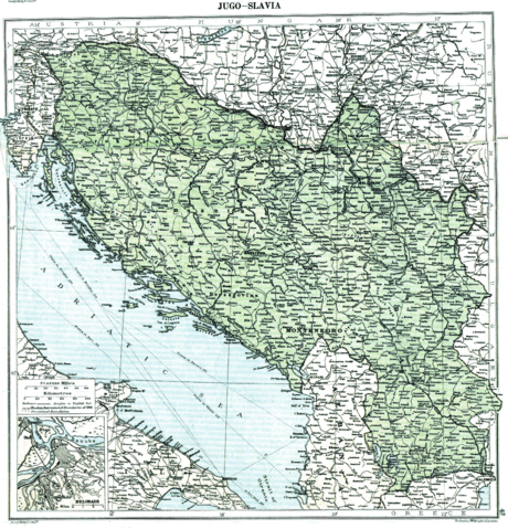
Map of Yugoslavia ( Kingdom of Serbs, Croats and Slovenes) in 1919, showing the provisional borders in the aftermath of World War I, after the dissolution of Austria-Hungary and the incorporation of Montenegro and before the treaties of Neuilly-sur-Seine, Trianon and Rapallo. Published in 1920 by the London Geographical Institute.
This uploaded map is a photoshopped version of the original image located at hipkiss.org. According to the site, there are no copyrights to this map.
Licensing
 |
This image is in the public domain in the United States. In most cases, this means that it was first published prior to January 1, 1923 (see the template documentation for more cases). Other jurisdictions may have other rules, and this image might not be in the public domain outside the United States. See Wikipedia:Public domain and Wikipedia:Copyrights for more details. |
File history
Click on a date/time to view the file as it appeared at that time.
| Date/Time | Dimensions | User | Comment | |
|---|---|---|---|---|
| current | 23:29, 3 July 2008 | 3,286×3,424 (3.02 MB) | Jklamo ( Talk | contribs) | (more photoshopped) |
| revert | 19:36, 10 April 2008 | 3,348×3,500 (6.86 MB) | MaGioZal ( Talk | contribs) | (Map of Yugoslavia ( Kingdom of Serbs, Croats and Slovenes) in 1919, showing the provisional borders in the aftermath of World War II, after the dissolution of Austria-Hungary and the incorporation of Montenegro) |
See the setup instructions for more information.
File links
The following pages on Schools Wikipedia link to this image (list may be incomplete):
Categories: Images in the public domain in the United States