Image:Kurdish-inhabited area by CIA (1992).jpg
From Wikipedia, the free encyclopedia
Size of this preview: 587 × 479 pixels
Full resolution (982 × 802 pixels, file size: 630 KB, MIME type: image/jpeg)
| |
This is a file from the Wikimedia Commons. The description on its description page there is shown below. |
Summary
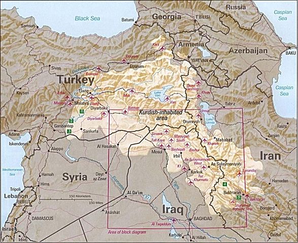
Kurdish-inhabited area by CIA (1992)
- Source: Perry-Castañeda Library Map Collection at The University of Texas at Austin
- License: Above a list of maps available for download, the web site has the text: The following maps were produced by the U.S. Central Intelligence Agency, unless otherwise indicated.. There is no indication that this map was not produced by the CIA.
Περίληψη
Περιοχές κατοικούμενες από Κούδρους CIA (1992)
- Πηγή: Perry-Castañeda Library Map Collection at The University of Texas at Austin
License
 |
This image is a work of a Central Intelligence Agency employee, taken or made during the course of the person's official duties. As a Work of the United States Government, all images created or made by the CIA are in the public domain, with the exception of classified information. |  |
File history
Click on a date/time to view the file as it appeared at that time.
| Date/Time | Dimensions | User | Comment | |
|---|---|---|---|---|
| current | 18:21, 9 February 2007 | 982×802 (630 KB) | White Cat | ('''Kurdish Lands (location map) 1992''' *Source: Perry-Castañeda Library Map Collection at The University of Texas at Austin [http://www.lib.utexas.edu/maps/middle_east.html] *License: Above a list of maps available for download, the web site has the te) |
File links
The following pages on Schools Wikipedia link to this image (list may be incomplete):
Categories: Maps of Kurdish-inhabited regions